
Faire un don
Équipez-vous pour votre prochaine aventure :
En tant que Partenaire Amazon, ce site perçoit une commission sur les achats éligibles sans surcoût pour vous.
Carte topographique Mount Galunggung
Cliquez sur la carte pour afficher l’altitude.
Faire un don
Équipez-vous pour votre prochaine aventure :
En tant que Partenaire Amazon, ce site perçoit une commission sur les achats éligibles sans surcoût pour vous.
Mount Galunggung
One plane, a British Airways aircraft carrying 240 passengers and traveling from Kuala Lumpur, Malaysia, to Perth, Australia, on 24 June 1982, accidentally entered the ash cloud at night, about 150 km (93 mi; 81 nmi) downwind of the volcano. All four engines failed due to the buildup of volcanic ash, and the aircraft descended for 16 minutes, losing 7,500 m (24,606 ft) of its 11,500 m (37,730 ft) altitude, until the crew managed to restart the engines and land in Jakarta.
Faire un don
Équipez-vous pour votre prochaine aventure :
En tant que Partenaire Amazon, ce site perçoit une commission sur les achats éligibles sans surcoût pour vous.
À propos de cette carte
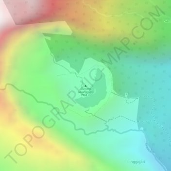
Nom : Carte topographique Mount Galunggung, altitude, relief.
Altitude moyenne : 1 286 m
Altitude minimum : 780 m
Altitude maximum : 2 076 m
Faire un don
Équipez-vous pour votre prochaine aventure :
En tant que Partenaire Amazon, ce site perçoit une commission sur les achats éligibles sans surcoût pour vous.