
Carte topographique Town of Kelly
Carte interactive
Cliquez sur la carte pour afficher l’altitude.
À propos de cette carte
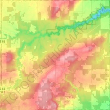
Nom : Carte topographique Town of Kelly, altitude, relief.
Lieu : Town of Kelly, Bayfield County, Wisconsin, United States (46.41359 -91.05098 46.50225 -90.92442)
Altitude moyenne : 281 m
Altitude minimum : 221 m
Altitude maximum : 325 m
Autres cartes topographiques
Cliquez sur une carte pour visualiser sa topographie, son altitude et son relief.
Raspberry Island
United States > Wisconsin > Bayfield County
Raspberry Island, Town of Russell, Bayfield County, Wisconsin, United States
Altitude moyenne : 182 m
Houghton Point
United States > Wisconsin > Bayfield County
Houghton Point, Town of Bayview, Bayfield County, Wisconsin, United States
Altitude moyenne : 192 m
Town of Namakagon
United States > Wisconsin > Bayfield County
Town of Namakagon, Bayfield County, Wisconsin, United States
Altitude moyenne : 443 m
Sand Bay
United States > Wisconsin > Bayfield County > Sand Bay
Sand Bay, Town of Russell, Bayfield County, Wisconsin, United States
Altitude moyenne : 209 m