
Carte topographique La Tannerie
Carte interactive
Cliquez sur la carte pour afficher l’altitude.
À propos de cette carte
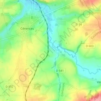
Nom : Carte topographique La Tannerie, altitude, relief.
Altitude moyenne : 52 m
Altitude minimum : 16 m
Altitude maximum : 108 m
Autres cartes topographiques
Cliquez sur une carte pour visualiser sa topographie, son altitude et son relief.
L'Hôtel au Roy
France > Normandie > Manche > Cérences
L'Hôtel au Roy, Cérences, Avranches, Manche, Normandie, France métropolitaine, 50510, France
Altitude moyenne : 51 m
Les Carrières
France > Normandie > Manche > Cérences
Les Carrières, Cérences, Avranches, Manche, Normandie, France métropolitaine, 50510, France
Altitude moyenne : 49 m
L'Hôtel Boschet
France > Normandie > Manche > Cérences
L'Hôtel Boschet, Cérences, Avranches, Manche, Normandie, France métropolitaine, 50510, France
Altitude moyenne : 49 m
Hameau Girot
France > Normandie > Manche > Cérences
Hameau Girot, Cérences, Avranches, Manche, Normandie, France métropolitaine, 50510, France
Altitude moyenne : 55 m