
Carte topographique Watauga County
Carte interactive
Cliquez sur la carte pour afficher l’altitude.
À propos de cette carte
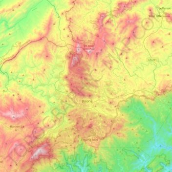
Nom : Carte topographique Watauga County, altitude, relief.
Lieu : Watauga County, North Carolina, United States of America (36.11148 -81.91808 36.39129 -81.45591)
Altitude moyenne : 984 m
Altitude minimum : 377 m
Altitude maximum : 1 777 m
As with most of North Carolina's High Country, the climate of Watauga County is that of a Humid continental climate characterized by considerably cooler and more drastic weather than other parts of the state. Dramatic and unexpected changes in the weather are not uncommon in the county, particularly when it comes to precipitation. This is partly due to the elevation of the county, and partly due to orographic lifting, which causes precipitation to fall more readily in Watauga County than in lowland areas to the east. Summers can be very warm with temperatures commonly in the 80s and on a rare occasion in the 90s. Snow usually starts in November, and there can be snow falls in April, although this is not usual. Windy conditions tend to be amplified across the county due to the rugged terrain and high elevation. Many people have noted that the winters of Watauga County tend to resemble those of the northern United States instead of the South.
Autres cartes topographiques
Cliquez sur une carte pour visualiser sa topographie, son altitude et son relief.
Blowing Rock
United States of America > North Carolina > Blowing Rock
Blowing Rock, Watauga County, North Carolina, 28605, United States of America
Altitude moyenne : 1 032 m
Outer Banks
United States of America > North Carolina
Outer Banks, Dare County, North Carolina, 27982, United States of America
Altitude moyenne : 0 m
Pinehurst
United States of America > North Carolina > Pinehurst
Pinehurst, Moore County, North Carolina, 28374, United States of America
Altitude moyenne : 138 m
Northwest
United States of America > North Carolina > Northwest
Northwest, Brunswick County, North Carolina, United States of America
Altitude moyenne : 16 m