
Carte topographique Usk
Carte interactive
Cliquez sur la carte pour afficher l’altitude.
À propos de cette carte
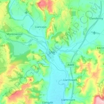
Nom : Carte topographique Usk, altitude, relief.
Lieu : Usk, Monmouthshire, Wales, NP15 1SD, United Kingdom (51.66451 -2.94264 51.74451 -2.86264)
Altitude moyenne : 66 m
Altitude minimum : 7 m
Altitude maximum : 239 m
The origin of the Welsh name Brynbuga (Welsh: [brɨ̞nˈbɨ̞ga]) is less certain. The local Brythonic name adopted into Latin as Burrium or Burrio was recorded as Brunebegy and Burenbegie in the 15th century. The modern name is likely an example of the linguistic metathesis common in Welsh Topography. Folk etymology has suggested the name derives from Bryn Buga (Buga's Hill) or Bryn Bugeilio (Shepherding Hill).
Autres cartes topographiques
Cliquez sur une carte pour visualiser sa topographie, son altitude et son relief.
Raglan
United Kingdom > Wales > Monmouthshire
Raglan, Monmouthshire, Wales, NP15 2DR, United Kingdom
Altitude moyenne : 60 m