
Carte topographique Plymouth County
Carte interactive
Cliquez sur la carte pour afficher l’altitude.
À propos de cette carte
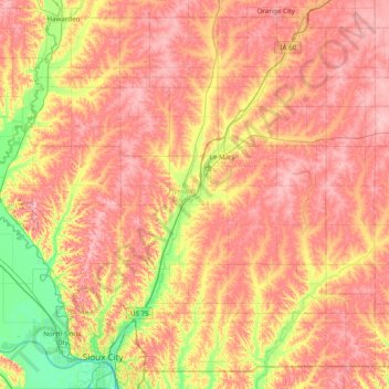
Nom : Carte topographique Plymouth County, altitude, relief.
Lieu : Plymouth County, Iowa, United States of America (42.56062 -96.63972 42.91058 -95.85803)
Altitude moyenne : 399 m
Altitude minimum : 323 m
Altitude maximum : 457 m
Autres cartes topographiques
Cliquez sur une carte pour visualiser sa topographie, son altitude et son relief.
Council Bluffs
United States of America > Iowa > Council Bluffs
Council Bluffs, Pottawattamie County, Iowa, United States of America
Altitude moyenne : 315 m
Des Moines
United States of America > Iowa > Des Moines
Des Moines, Polk County, Iowa, United States of America
Altitude moyenne : 264 m
Keystone
United States of America > Iowa > Keystone
Keystone, Benton County, Iowa, 52249, United States of America
Altitude moyenne : 272 m
Renwick
United States of America > Iowa > Renwick
Renwick, Humboldt County, Iowa, United States of America
Altitude moyenne : 347 m
Hawarden
United States of America > Iowa > Hawarden
Hawarden, Sioux County, Iowa, United States of America
Altitude moyenne : 365 m
Dedham
United States of America > Iowa > Dedham
Dedham, Carroll County, Iowa, United States of America
Altitude moyenne : 395 m
Riverton
United States of America > Iowa > Riverton
Riverton, Fremont County, Iowa, United States of America
Altitude moyenne : 292 m
Ames
United States of America > Iowa > Ames
Ames, Story County, Iowa, United States of America
Altitude moyenne : 292 m
Pottawattamie County
United States of America > Iowa
Pottawattamie County, Iowa, United States of America
Altitude moyenne : 357 m