
Carte topographique Santo Tomas
Carte interactive
Cliquez sur la carte pour afficher l’altitude.
À propos de cette carte
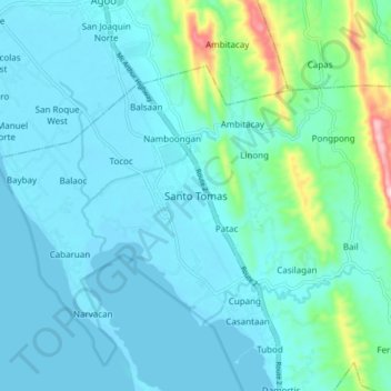
Nom : Carte topographique Santo Tomas, altitude, relief.
Lieu : Santo Tomas, La Union, Ilocos Region, 2505, Philippines (16.24235 120.34672 16.32235 120.42672)
Altitude moyenne : 40 m
Altitude minimum : -1 m
Altitude maximum : 281 m
Autres cartes topographiques
Cliquez sur une carte pour visualiser sa topographie, son altitude et son relief.
Sungyot Island
Philippines > La Union > Santo Tomas
Sungyot Island, Santo Tomas, La Union, Ilocos Region, Philippines
Altitude moyenne : 0 m
Cupang
Philippines > La Union > Santo Tomas
Cupang, Santo Tomas, La Union, Ilocos Region, Philippines
Altitude moyenne : 23 m
Tubod
Philippines > La Union > Santo Tomas
Tubod, Santo Tomas, La Union, Ilocos Region, Philippines
Altitude moyenne : 24 m
Agoo-Damortis Protected Landscape and Seascape
Philippines > La Union > Santo Tomas
Agoo-Damortis Protected Landscape and Seascape, Santo Tomas, La Union, Ilocos Region, Philippines
Altitude moyenne : 9 m
Damortis
Philippines > La Union > Santo Tomas
Damortis, Santo Tomas, La Union, Philippines
Altitude moyenne : 25 m
Parasapas
Philippines > La Union > Santo Tomas
Parasapas, Santo Tomas, La Union, Ilocos Region, 2508, Philippines
Altitude moyenne : 202 m