
Carte topographique Manarcadu
Carte interactive
Cliquez sur la carte pour afficher l’altitude.
À propos de cette carte
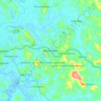
Nom : Carte topographique Manarcadu, altitude, relief.
Lieu : Manarcadu, Kottayam, Kerala, 686019, India (9.54778 76.54227 9.62778 76.62227)
Altitude moyenne : 23 m
Altitude minimum : -2 m
Altitude maximum : 129 m
Autres cartes topographiques
Cliquez sur une carte pour visualiser sa topographie, son altitude et son relief.
Sankranthi
India > Kerala > Kottayam > Kottayam
Sankranthi, Kumaranalloor, Kottayam, Kerala, 686028, India
Altitude moyenne : 15 m
Ettumanoor
Ettumanoor, Kottayam, Kerala, 686631, India
Altitude moyenne : 22 m
Thiruvanchoor
India > Kerala > Kottayam > Thiruvanchoor
Thiruvanchoor, Kottayam, Kerala, 686032, India
Altitude moyenne : 11 m
Illickal Thazhe
India > Kerala > Kottayam > Kozhikombu > Illickal Thazhe
Illickal Thazhe, Kozhikombu, Kottayam, Kerala, 686635, India
Altitude moyenne : 46 m