
Carte topographique Murphy
Carte interactive
Cliquez sur la carte pour afficher l’altitude.
À propos de cette carte
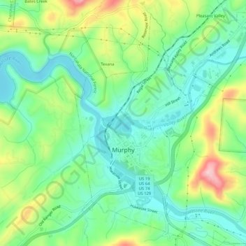
Nom : Carte topographique Murphy, altitude, relief.
Lieu : Murphy, Cherokee County, North Carolina, United States (35.07100 -84.04487 35.11326 -84.00244)
Altitude moyenne : 514 m
Altitude minimum : 448 m
Altitude maximum : 648 m
Murphy has a humid subtropical climate, (Cfa) according to the Köppen classification, with hot, humid summers and cool to mild winters, with low temperatures significantly cooler than other parts of the Southeast, due in part to the elevation. Like the rest of the southeastern U.S., Murphy receives abundant rainfall, greatest in winter and enhanced by the elevation. Receiving as much as 100 inches per year in some parts, areas of Cherokee County are considered part of the Appalachian temperate rainforest. Blizzards are rare but possible; the 1993 Storm of the Century dropped 15 inches (38 cm) in 24 hours with more snowfall continuing up to 38" in some areas, causing widespread power outages and natural disasters.
Autres cartes topographiques
Cliquez sur une carte pour visualiser sa topographie, son altitude et son relief.
Andrews
United States > North Carolina > Cherokee County
Andrews, Cherokee County, North Carolina, 28901, United States
Altitude moyenne : 593 m
Pleasant Valley
United States > North Carolina > Cherokee County
Pleasant Valley, Cherokee County, North Carolina, United States
Altitude moyenne : 550 m
Peachtree
United States > North Carolina > Cherokee County
Peachtree, Cherokee County, North Carolina, United States
Altitude moyenne : 535 m
Ebenezer
United States > North Carolina > Cherokee County
Ebenezer, Cherokee County, North Carolina, United States
Altitude moyenne : 572 m
Pleasant Hill
United States > North Carolina > Cherokee County > Pleasant Hill
Pleasant Hill, Cherokee County, North Carolina, United States
Altitude moyenne : 464 m
Murphy
United States > North Carolina > Cherokee County > Murphy
Murphy, Cherokee County, North Carolina, United States
Altitude moyenne : 528 m
Topton
United States > North Carolina > Cherokee County > Topton
Topton, Cherokee County, North Carolina, United States
Altitude moyenne : 980 m
Persimmon Creek
United States > North Carolina > Cherokee County
Persimmon Creek, Cherokee County, North Carolina, United States
Altitude moyenne : 490 m
Marble
United States > North Carolina > Cherokee County
Marble, Cherokee County, North Carolina, 28905, United States
Altitude moyenne : 571 m