
Carte topographique Alps
Carte interactive
Cliquez sur la carte pour afficher l’altitude.
À propos de cette carte
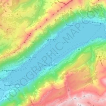
Nom : Carte topographique Alps, altitude, relief.
Lieu : Alps, Brienzersee, Bellagio, Como, Lombardy, 3855, Italy (46.68797 7.88470 46.75796 8.04990)
Altitude moyenne : 1 284 m
Altitude minimum : 555 m
Altitude maximum : 2 703 m
The altitude and size of the range affects the climate in Europe; in the mountains precipitation levels vary greatly and climatic conditions consist of distinct zones. Wildlife such as ibex live in the higher peaks to elevations of 3,400 m (11,155 ft), and plants such as Edelweiss grow in rocky areas in lower elevations as well as in higher elevations. Evidence of human habitation in the Alps goes back to the Palaeolithic era. A mummified man, determined to be 5,000 years old, was discovered on a glacier at the Austrian–Italian border in 1991.
Autres cartes topographiques
Cliquez sur une carte pour visualiser sa topographie, son altitude et son relief.