
Carte topographique Château du Hohnack
Carte interactive
Cliquez sur la carte pour afficher l’altitude.
À propos de cette carte
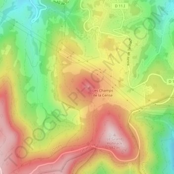
Nom : Carte topographique Château du Hohnack, altitude, relief.
Altitude moyenne : 775 m
Altitude minimum : 577 m
Altitude maximum : 964 m
Autres cartes topographiques
Cliquez sur une carte pour visualiser sa topographie, son altitude et son relief.
Le Grand Hohnack
France > Grand Est > Labaroche
Le Grand Hohnack, Labaroche, Colmar-Ribeauvillé, Haut-Rhin, Grand Est, France métropolitaine, 68910, France
Altitude moyenne : 763 m