
Carte topographique Grant County
Carte interactive
Cliquez sur la carte pour afficher l’altitude.
À propos de cette carte
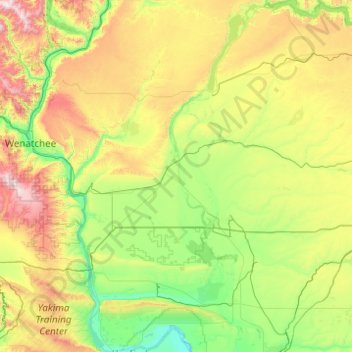
Nom : Carte topographique Grant County, altitude, relief.
Lieu : Grant County, Washington, United States (46.62524 -120.04287 47.96215 -118.97350)
Altitude moyenne : 563 m
Altitude minimum : 111 m
Altitude maximum : 2 111 m
Autres cartes topographiques
Cliquez sur une carte pour visualiser sa topographie, son altitude et son relief.
Low Gap
United States > Washington > Grant County
Low Gap, Grant County, Washington, United States
Altitude moyenne : 418 m
Lynnwood
United States > Washington > Snohomish County
Lynnwood, Snohomish County, Washington, 98037, United States
Altitude moyenne : 121 m
Peshastin
United States > Washington > Chelan County
Peshastin, Chelan County, Washington, 98847, United States
Altitude moyenne : 418 m
Pasco
United States > Washington > Franklin County
Pasco, Franklin County, Washington, 99301, United States
Altitude moyenne : 141 m
Seattle
United States > Washington > King County
Seattle, King County, Washington, United States
Altitude moyenne : 40 m
Quincy
United States > Washington > Grant County
Quincy, Grant County, Washington, United States
Altitude moyenne : 400 m
Table Mountain Natural Resources Conservation Area
United States > Washington > Skamania County
Table Mountain Natural Resources Conservation Area, CG-2020, Skamania County, Washington, United States
Altitude moyenne : 574 m
Ocean Shores
United States > Washington > Grays Harbor County
Ocean Shores, Grays Harbor County, Washington, 98569, United States
Altitude moyenne : 1 m
Pateros
United States > Washington > Okanogan County
Pateros, Okanogan County, Washington, 98846, United States
Altitude moyenne : 334 m
Wenatchee
United States > Washington > Chelan County
Wenatchee, Chelan County, Washington, 98801, United States
Altitude moyenne : 302 m
Cashmere
United States > Washington > Chelan County
Cashmere, Chelan County, Washington, United States
Altitude moyenne : 298 m
Nantes Park
United States > Washington > King County > Seattle
Nantes Park, West Seattle, Seattle, King County, Washington, United States
Altitude moyenne : 53 m
Avalanche Lake
United States > Washington > King County
Avalanche Lake, King County, Washington, United States
Altitude moyenne : 1 573 m
Devils Peak
United States > Washington > Snohomish County
Devils Peak, Snohomish County, Washington, United States
Altitude moyenne : 1 198 m
Royal City
United States > Washington > Grant County
Royal City, Grant County, Washington, 99357, United States
Altitude moyenne : 313 m
Cathedral Peak
United States > Washington > Okanogan County
Cathedral Peak, Okanogan County, Washington, United States
Altitude moyenne : 2 231 m
Lynnwood
United States > Washington > Snohomish County > Lynnwood > Lynnwood
Lynnwood, Snohomish County, Washington, 98036, United States
Altitude moyenne : 112 m
Bellingham
United States > Washington > Whatcom County > Bellingham
Bellingham, Whatcom County, Washington, 98225-3243, United States
Altitude moyenne : 129 m
Lewis Glacier
Lewis Glacier, Skagit County, Washington, United States
Altitude moyenne : 2 030 m
Inglewood
United States > Washington > Kirkland > Inglewood
Inglewood, Kirkland, King County, Washington, 98028, United States
Altitude moyenne : 90 m
Mount Stuart
Mount Stuart, Chelan County, Washington, United States
Altitude moyenne : 2 109 m
Kitsap County
Kitsap County, Washington, United States
Altitude moyenne : 138 m
Wilderness
United States > Washington > Wilderness
Wilderness, King County, Washington, 98038, United States
Altitude moyenne : 154 m
Okanogan County
Okanogan County, Washington, United States
Altitude moyenne : 1 094 m
Mount Rainier
Mount Rainier, Pierce County, Washington, United States
Altitude moyenne : 3 938 m