
Carte topographique Deggingen
Carte interactive
Cliquez sur la carte pour afficher l’altitude.
Deggingen
The municipality (Gemeinde) of Deggingen is found in the district of Göppingen, in Baden-Württemberg, one of the 16 States of the Federal Republic of Germany. Deggingen is physically located in the upper Fils river valley, in the Filsalb region of the Middle Kuppenalb . Elevation above sea level in the municipal area ranges from a high of 777 meters (2,549 ft) Normalnull (NN) to a low of 465 meters (1,526 ft) NN.
À propos de cette carte
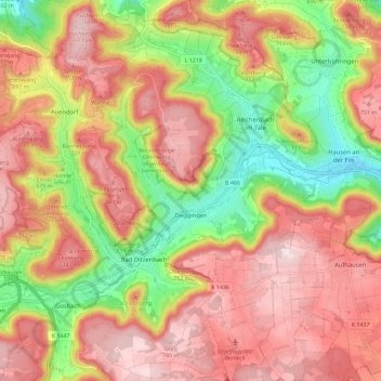
Nom : Carte topographique Deggingen, altitude, relief.
Altitude moyenne : 643 m
Altitude minimum : 456 m
Altitude maximum : 787 m