
Carte topographique Masyaf
Carte interactive
Cliquez sur la carte pour afficher l’altitude.
Masyaf
Masyaf is situated along the foothills of the eastern slopes of the Jabal Ansariyah coastal mountain range. The average elevation of Masyaf is 485 meters. It is just west of the al-Ghab Plain. The area is marked by gardens, orchards and fields of wheat and barley which are cultivated by local residents. To the north and south of Masyaf flow seasonal streams which feed into a tributary of the Orontes River, called al-Sarout.
À propos de cette carte
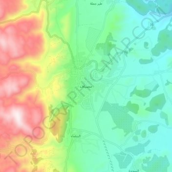
Nom : Carte topographique Masyaf, altitude, relief.
Altitude moyenne : 588 m
Altitude minimum : 312 m
Altitude maximum : 1 147 m