
Carte topographique Tavropos (Megdova)
Carte interactive
Cliquez sur la carte pour afficher l’altitude.
À propos de cette carte
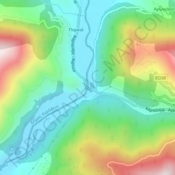
Nom : Carte topographique Tavropos (Megdova), altitude, relief.
Altitude moyenne : 494 m
Altitude minimum : 278 m
Altitude maximum : 922 m
Autres cartes topographiques
Cliquez sur une carte pour visualiser sa topographie, son altitude et son relief.
Tavropos (Megdova)
Griechenland > Thessalien - Mittelgriechenland > Regionalbezirk Evrytania > Δημοτική Ενότητα Καρπενησίου
Tavropos (Megdova), Κ. Στενώματος, Δημοτική Ενότητα Καρπενησίου, Δήμος Καρπενησίου, Regionalbezirk Evrytania, Region Mittelgriechenland, Thessalien - Mittelgriechenland, Griechenland
Altitude moyenne : 497 m
Tavropos (Megdova)
Griechenland > Thessalien - Mittelgriechenland > Regionalbezirk Evrytania
Tavropos (Megdova), Κ. Βράχας, Δήμος Καρπενησίου, Regionalbezirk Evrytania, Region Mittelgriechenland, Thessalien - Mittelgriechenland, Griechenland
Altitude moyenne : 694 m