
Carte topographique L'Anse Township
Carte interactive
Cliquez sur la carte pour afficher l’altitude.
À propos de cette carte
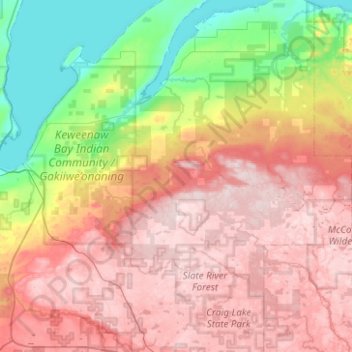
Nom : Carte topographique L'Anse Township, altitude, relief.
Altitude moyenne : 388 m
Altitude minimum : 175 m
Altitude maximum : 600 m
Autres cartes topographiques
Cliquez sur une carte pour visualiser sa topographie, son altitude et son relief.
Mount Arvon
United States > Michigan > Baraga County
Mount Arvon, L'Anse Township, Baraga County, Michigan, United States
Altitude moyenne : 526 m
Aura
United States > Michigan > Baraga County > Aura
Aura, L'Anse Township, Baraga County, Michigan, United States
Altitude moyenne : 240 m
L'Anse
United States > Michigan > Baraga County > L'Anse
L'Anse, L'Anse Township, Baraga County, Michigan, 49946, United States
Altitude moyenne : 224 m
Ruth Lake
United States > Michigan > Baraga County > Three Lakes
Ruth Lake, Three Lakes, Spurr Township, Baraga County, Michigan, United States
Altitude moyenne : 507 m