
Faire un don
Équipez-vous pour votre prochaine aventure :
En tant que Partenaire Amazon, ce site perçoit une commission sur les achats éligibles sans surcoût pour vous.
Carte topographique Pulga
Cliquez sur la carte pour afficher l’altitude.
Faire un don
Équipez-vous pour votre prochaine aventure :
En tant que Partenaire Amazon, ce site perçoit une commission sur les achats éligibles sans surcoût pour vous.
À propos de cette carte
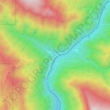
Nom : Carte topographique Pulga, altitude, relief.
Lieu : Pulga, Butte County, California, 95980, United States (39.78294 -121.46858 39.82294 -121.42858)
Altitude moyenne : 750 m
Altitude minimum : 370 m
Altitude maximum : 1 200 m
Faire un don
Équipez-vous pour votre prochaine aventure :
En tant que Partenaire Amazon, ce site perçoit une commission sur les achats éligibles sans surcoût pour vous.
Autres cartes topographiques
Cliquez sur une carte pour visualiser sa topographie, son altitude et son relief.
Paradise
United States > California > Butte County
Paradise lies within the foothills of the Sierra Nevada mountain range, at an elevation that varies between 900 and 2,300 feet (275 to 700 meters) above sea level. The town is perched on a broad ridge, with steep canyons on either side—these are carved by the Feather River to the east and Butte Creek to the…
Altitude moyenne : 464 m
Chico
United States > California > Butte County
An altitude record for unmanned gas balloons was set in Chico in October 1972 (51.8 km or 32.2 mi). The record was broken on May 23, 2002.
Altitude moyenne : 95 m
Faire un don
Équipez-vous pour votre prochaine aventure :
En tant que Partenaire Amazon, ce site perçoit une commission sur les achats éligibles sans surcoût pour vous.
Paradise
United States > California > Butte County
The town is spread out on a wide ridge between deep canyons formed by the west branch of the Feather River to the east and Butte Creek to the west. The Paradise area extends northward to include the unincorporated town of Magalia, as well as Stirling City, eleven miles (18 km) north. Elevation of the area…
Altitude moyenne : 464 m
Chico
United States > California > Butte County
An altitude record for unmanned gas balloons was set in Chico in October 1972 (51.8 km or 32.2 mi). The record was broken on May 23, 2002.
Altitude moyenne : 95 m
Faire un don
Équipez-vous pour votre prochaine aventure :
En tant que Partenaire Amazon, ce site perçoit une commission sur les achats éligibles sans surcoût pour vous.
Paradise
United States > California > Butte County
The town is spread out on a wide ridge between deep canyons formed by the west branch of the Feather River to the east and Butte Creek to the west. The Paradise area extends northward to include the unincorporated town of Magalia, as well as Stirling City, eleven miles (18 km) north. Elevation of the area…
Altitude moyenne : 464 m