
Carte topographique Coos County
Carte interactive
Cliquez sur la carte pour afficher l’altitude.
À propos de cette carte
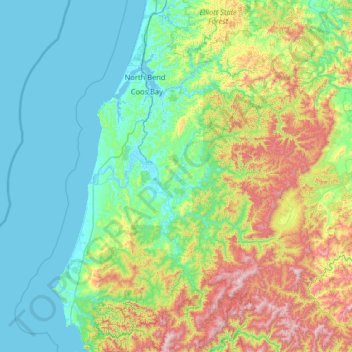
Nom : Carte topographique Coos County, altitude, relief.
Lieu : Coos County, Oregon, United States of America (42.66638 -124.55228 43.61145 -123.70156)
Altitude moyenne : 266 m
Altitude minimum : -3 m
Altitude maximum : 1 257 m
Autres cartes topographiques
Cliquez sur une carte pour visualiser sa topographie, son altitude et son relief.
Hillsboro
United States of America > Oregon > Hillsboro
Hillsboro, Washington County, Oregon, United States of America
Altitude moyenne : 53 m
Tillamook County
United States of America > Oregon
Tillamook County, Oregon, United States of America
Altitude moyenne : 236 m
Clackamas County
United States of America > Oregon
Clackamas County, Oregon, United States of America
Altitude moyenne : 660 m
Multnomah County
United States of America > Oregon
Multnomah County, Oregon, United States of America
Altitude moyenne : 334 m