
Carte topographique Phthiotis Regional Unit
Carte interactive
Cliquez sur la carte pour afficher l’altitude.
À propos de cette carte
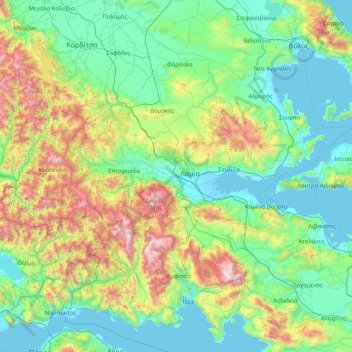
Nom : Carte topographique Phthiotis Regional Unit, altitude, relief.
Altitude moyenne : 480 m
Altitude minimum : -3 m
Altitude maximum : 2 440 m
Autres cartes topographiques
Cliquez sur une carte pour visualiser sa topographie, son altitude et son relief.
Komma
Greece > Thessaly and Central Greece > Phthiotis Regional Unit > Municipal Unit of Lamia
Komma, Municipal Unit of Lamia, Lamia Municipality, Phthiotis Regional Unit, Central Greece, Thessaly and Central Greece, 351 00, Greece
Altitude moyenne : 12 m
Ypati
Greece > Thessaly and Central Greece > Phthiotis Regional Unit > Δημοτική Ενότητα Υπάτης
Ypati, Δημοτική Ενότητα Υπάτης, Lamia Municipality, Phthiotis Regional Unit, Central Greece, Thessaly and Central Greece, 350 16, Greece
Altitude moyenne : 488 m
Varka
Greece > Thessaly and Central Greece > Phthiotis Regional Unit > Δημοτική Ενότητα Υπάτης > Loutra Ypatis
Varka, Κ. Λουτρών Υπάτης, Loutra Ypatis, Δημοτική Ενότητα Υπάτης, Lamia Municipality, Phthiotis Regional Unit, Central Greece, Thessaly and Central Greece, 350 16, Greece
Altitude moyenne : 166 m
Φούρνοι
Greece > Thessaly and Central Greece > Phthiotis Regional Unit > Αχλάδι
Φούρνοι, Κ. Ραχών, Αχλάδι, Stylida Municipality, Phthiotis Regional Unit, Central Greece, Thessaly and Central Greece, 353 00, Greece
Altitude moyenne : 22 m
Σκάρφεια
Greece > Thessaly and Central Greece > Phthiotis Regional Unit > Σκάρφεια
Σκάρφεια, Kamena Vourla Municipality, Phthiotis Regional Unit, Central Greece, Thessaly and Central Greece, 350 09, Greece
Altitude moyenne : 20 m
Lamia
Greece > Thessaly and Central Greece > Phthiotis Regional Unit
Lamia, Municipal Unit of Lamia, Lamia Municipality, Phthiotis Regional Unit, Central Greece, Thessaly and Central Greece, 351 00, Greece
Altitude moyenne : 534 m