
Carte topographique Simmering
Carte interactive
Cliquez sur la carte pour afficher l’altitude.
À propos de cette carte
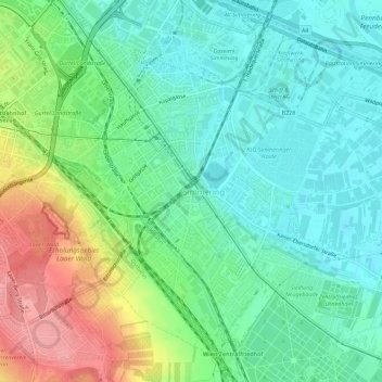
Nom : Carte topographique Simmering, altitude, relief.
Lieu : Simmering, Vienna, 1110, Austria (48.15173 16.39530 48.18728 16.45195)
Altitude moyenne : 184 m
Altitude minimum : 151 m
Altitude maximum : 253 m
The district lies in the southern part of Vienna. It borders the Danube and Danube Canal to the east and the East railway to the west. Of all the districts, Simmering is the lowest district in terms of elevation.
Autres cartes topographiques
Cliquez sur une carte pour visualiser sa topographie, son altitude et son relief.
KG Stammersdorf
KG Stammersdorf, Floridsdorf, Vienna, 1210, Austria
Altitude moyenne : 196 m
Schonbrunn Palace
Schonbrunn Palace, 47, Schönbrunner Schlossstraße, KG Schönbrunn, Hietzing, Vienna, 1130, Austria
Altitude moyenne : 214 m
Herweghpark
Herweghpark, Matzleinsdorf, KG Margareten, Margareten, Vienna, 1050, Austria
Altitude moyenne : 208 m
Kongressbad
Kongressbad, 7a, Julius-Meinl-Gasse, KG Ottakring, Ottakring, Vienna, 1160, Austria
Altitude moyenne : 242 m