
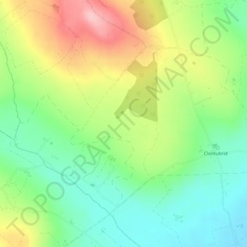
Carte topographique Tifeaghna (Mt Garrett)
Carte interactive
Cliquez sur la carte pour afficher l’altitude.
À propos de cette carte
Nom : Carte topographique Tifeaghna (Mt Garrett), altitude, relief.
Altitude moyenne : 145 m
Altitude minimum : 79 m
Altitude maximum : 244 m
Autres cartes topographiques
Cliquez sur une carte pour visualiser sa topographie, son altitude et son relief.
Clomantagh (Mt Garrett)
Clomantagh (Mt Garrett), Clomantagh, The Municipal District of Castlecomer, Comté de Kilkenny, Leinster, Irlande
Altitude moyenne : 217 m
Agha
Agha, Rathcoole, The Municipal District of Castlecomer, Comté de Kilkenny, Leinster, Irlande
Altitude moyenne : 213 m
The Municipal District of Kilkenny City
The Municipal District of Kilkenny City, Comté de Kilkenny, Leinster, Irlande
Altitude moyenne : 84 m
Westmoreland
Westmoreland, Aghaviller, The Municipal District of Callan — Thomastown, Comté de Kilkenny, Leinster, Irlande
Altitude moyenne : 134 m
Kilkenny
Kilkenny, Comté de Kilkenny, Leinster, Irlande
Altitude moyenne : 62 m