
Carte topographique Gun Lake
Carte interactive
Cliquez sur la carte pour afficher l’altitude.
À propos de cette carte
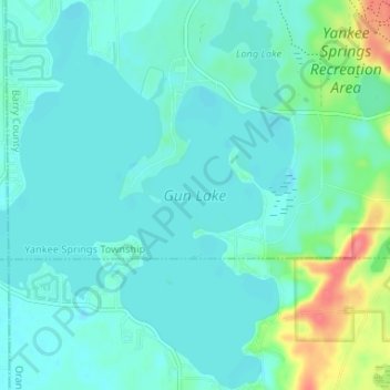
Nom : Carte topographique Gun Lake, altitude, relief.
Altitude moyenne : 234 m
Altitude minimum : 222 m
Altitude maximum : 285 m
Autres cartes topographiques
Cliquez sur une carte pour visualiser sa topographie, son altitude et son relief.
Hastings Township
United States > Michigan > Barry County
Hastings Township, Barry County, Michigan, United States
Altitude moyenne : 265 m
Hastings
United States > Michigan > Barry County
Hastings, Barry County, Michigan, 49058, United States
Altitude moyenne : 252 m
Thornapple River
United States > Michigan > Barry County > Irving
Thornapple River, Irving, Irving Township, Barry County, Michigan, United States
Altitude moyenne : 236 m