
Carte topographique South Glengarry
Carte interactive
Cliquez sur la carte pour afficher l’altitude.
À propos de cette carte
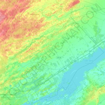
Nom : Carte topographique South Glengarry, altitude, relief.
Altitude moyenne : 65 m
Altitude minimum : 43 m
Altitude maximum : 117 m
Autres cartes topographiques
Cliquez sur une carte pour visualiser sa topographie, son altitude et son relief.
North Glengarry
Canada > Ontario > Stormont, Dundas and Glengarry Counties
North Glengarry, Stormont, Dundas and Glengarry Counties, Est de l'Ontario, Ontario, Canada
Altitude moyenne : 78 m
Morrisburg
Canada > Ontario > Stormont, Dundas and Glengarry Counties > South Dundas
Morrisburg, South Dundas, Stormont, Dundas and Glengarry Counties, Est de l'Ontario, Ontario, K0C 1X0, Canada
Altitude moyenne : 79 m