
Carte topographique Galston
Carte interactive
Cliquez sur la carte pour afficher l’altitude.
À propos de cette carte
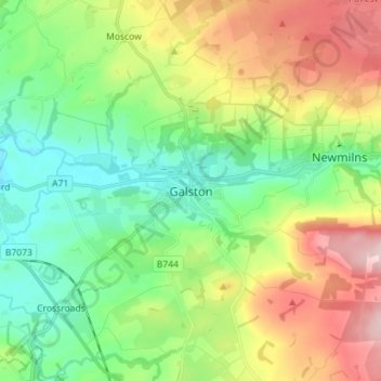
Nom : Carte topographique Galston, altitude, relief.
Lieu : Galston, East Ayrshire, Scotland, KA4 8HG, United Kingdom (55.56041 -4.41975 55.64041 -4.33975)
Altitude moyenne : 126 m
Altitude minimum : 30 m
Altitude maximum : 297 m
Autres cartes topographiques
Cliquez sur une carte pour visualiser sa topographie, son altitude et son relief.
Kilmarnock
United Kingdom > Scotland > East Ayrshire
Kilmarnock, East Ayrshire, Scotland, KA1 1HZ, United Kingdom
Altitude moyenne : 56 m
Cumnock
United Kingdom > Scotland > East Ayrshire
Cumnock, East Ayrshire, Scotland, KA18 1AY, United Kingdom
Altitude moyenne : 187 m
Dalmellington
United Kingdom > Scotland > East Ayrshire
Dalmellington, East Ayrshire, Scotland, KA6 7QU, United Kingdom
Altitude moyenne : 285 m
Dunlop
United Kingdom > Scotland > East Ayrshire
Dunlop, East Ayrshire, Scotland, KA3 4AF, United Kingdom
Altitude moyenne : 132 m