
Carte topographique XII.
Carte interactive
Cliquez sur la carte pour afficher l’altitude.
À propos de cette carte
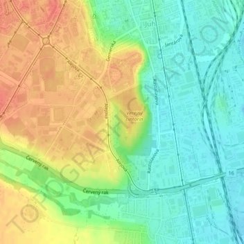
Nom : Carte topographique XII., altitude, relief.
Altitude moyenne : 218 m
Altitude minimum : 195 m
Altitude maximum : 246 m
Autres cartes topographiques
Cliquez sur une carte pour visualiser sa topographie, son altitude et son relief.
Bezirk Kaschau IV
Slowakei > Kaschauer Landschaftsverband > Bezirk Kaschau IV
Bezirk Kaschau IV, Kaschau, Kaschauer Landschaftsverband, Ostslowakei, Slowakei
Altitude moyenne : 223 m
Barca
Slowakei > Kaschauer Landschaftsverband > Bezirk Kaschau IV
Barca, Košice - mestská časť Barca, Bezirk Kaschau IV, Kaschau, Kaschauer Landschaftsverband, Ostslowakei, Slowakei
Altitude moyenne : 218 m