
Faire un don
Équipez-vous pour votre prochaine aventure :
En tant que Partenaire Amazon, ce site perçoit une commission sur les achats éligibles sans surcoût pour vous.
Carte topographique Sunshine Coast
Cliquez sur la carte pour afficher l’altitude.
Faire un don
Équipez-vous pour votre prochaine aventure :
En tant que Partenaire Amazon, ce site perçoit une commission sur les achats éligibles sans surcoût pour vous.
Sunshine Coast
The Sunshine Coast in Queensland, Australia, showcases a diverse topography that harmoniously blends coastal plains with rugged hinterlands. Along its eastern edge, the region features expansive sandy beaches and coastal dunes that transition smoothly into fertile lowlands. Inland, the terrain becomes more varied and elevated, highlighted by prominent mountain ranges. The Blackall Range, reaching elevations up to 561 meters (1,841 feet), is characterized by lush rainforests, waterfalls, and rich red basalt soils, remnants of ancient volcanic activity. To the west, the Conondale Range, peaking at Mount Langley (868 meters or 2,848 feet), forms part of the Great Dividing Range and is predominantly covered by state forests and national parks. Further south, the distinctive Glass House Mountains, including Mount Beerwah (556 meters or 1,824 feet) and Mount Tibrogargan (364 meters or 1,194 feet), are volcanic plugs that rise sharply from the coastal plain, offering striking geological formations. This varied terrain supports diverse ecosystems, from coastal mangroves to subtropical rainforests, making the Sunshine Coast a region of significant ecological and geological interest.
Faire un don
Équipez-vous pour votre prochaine aventure :
En tant que Partenaire Amazon, ce site perçoit une commission sur les achats éligibles sans surcoût pour vous.
À propos de cette carte
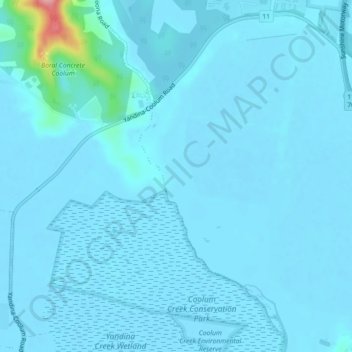
Nom : Carte topographique Sunshine Coast, altitude, relief.
Altitude moyenne : 109 m
Altitude minimum : -5 m
Altitude maximum : 819 m
Faire un don
Équipez-vous pour votre prochaine aventure :
En tant que Partenaire Amazon, ce site perçoit une commission sur les achats éligibles sans surcoût pour vous.
Autres cartes topographiques
Cliquez sur une carte pour visualiser sa topographie, son altitude et son relief.
Faire un don
Équipez-vous pour votre prochaine aventure :
En tant que Partenaire Amazon, ce site perçoit une commission sur les achats éligibles sans surcoût pour vous.
Faire un don
Équipez-vous pour votre prochaine aventure :
En tant que Partenaire Amazon, ce site perçoit une commission sur les achats éligibles sans surcoût pour vous.
Faire un don
Équipez-vous pour votre prochaine aventure :
En tant que Partenaire Amazon, ce site perçoit une commission sur les achats éligibles sans surcoût pour vous.
Faire un don
Équipez-vous pour votre prochaine aventure :
En tant que Partenaire Amazon, ce site perçoit une commission sur les achats éligibles sans surcoût pour vous.