
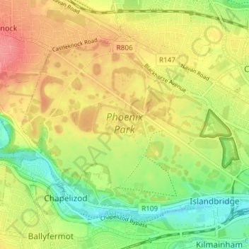
Carte topographique Phoenix Park
Carte interactive
Cliquez sur la carte pour afficher l’altitude.
À propos de cette carte
Nom : Carte topographique Phoenix Park, altitude, relief.
Altitude moyenne : 40 m
Altitude minimum : 3 m
Altitude maximum : 74 m
Autres cartes topographiques
Cliquez sur une carte pour visualiser sa topographie, son altitude et son relief.
Pro-Cathederal
Pro-Cathederal, North City ED, Dublin, Dublin 1, Leinster, Ireland
Altitude moyenne : 13 m
African Savanna
African Savanna, Phoenix Park ED, Dublin 8, Dublin, County Dublin, Leinster, D08 HN3X, Ireland
Altitude moyenne : 35 m
Berkeley Street
Berkeley Street, Inns Quay B ED, Dublin, Dublin 1, Leinster, Ireland
Altitude moyenne : 18 m
St. George's Parish
St. George's Parish, Inns Quay A ED, Dublin, Dublin 1, Leinster, Ireland
Altitude moyenne : 16 m
Sandymount
Sandymount, Pembroke East C ED, Dublin 4, Dublin, County Dublin, Leinster, Ireland
Altitude moyenne : 5 m
Ballybough
Ballybough, Clontarf West E ED, Dublin 3, Dublin, County Dublin, Leinster, Ireland
Altitude moyenne : 15 m
Beggarsbush
Beggarsbush, Pembroke West A ED, Dublin 4, Dublin, County Dublin, Leinster, Ireland
Altitude moyenne : 7 m
North Bull Island
North Bull Island, Raheny St. Assam ED, Dublin 5, Dublin, County Dublin, Leinster, Ireland
Altitude moyenne : 2 m