
Carte topographique Heidelberg
Cliquez sur la carte pour afficher l’altitude.
À propos de cette carte
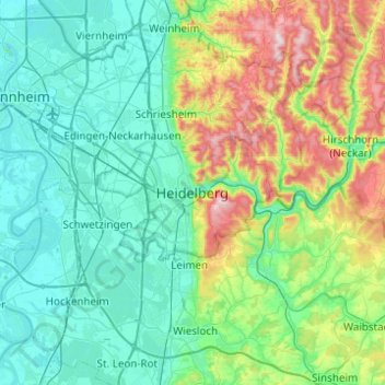
Nom : Carte topographique Heidelberg, altitude, relief.
Altitude moyenne : 200 m
Altitude minimum : 87 m
Altitude maximum : 602 m
Autres cartes topographiques
Cliquez sur une carte pour visualiser sa topographie, son altitude et son relief.
Heidelberg Castle
Germany > Baden-Württemberg > Heidelberg > Königstuhl
All of these works are for the most part superficial and do not contain much information. In 1615, Merian's Topographia Palatinatus Rheni described Prince Elector Ludwig V as he "started building a new castle one hundred and more years ago". Most of the descriptions of the castle up until the 18th century are…
Altitude moyenne : 280 m