
Carte topographique Musselburgh
Carte interactive
Cliquez sur la carte pour afficher l’altitude.
À propos de cette carte
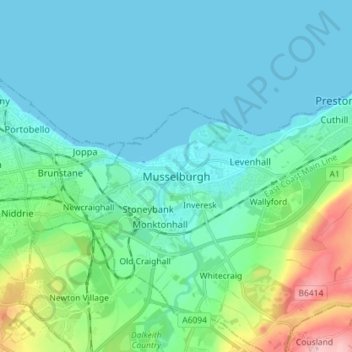
Nom : Carte topographique Musselburgh, altitude, relief.
Lieu : Musselburgh, East Lothian, Scotland, EH21 7DX, United Kingdom (55.90212 -3.09385 55.98212 -3.01385)
Altitude moyenne : 32 m
Altitude minimum : 0 m
Altitude maximum : 172 m
Autres cartes topographiques
Cliquez sur une carte pour visualiser sa topographie, son altitude et son relief.
Tranent
United Kingdom > Scotland > East Lothian
Tranent, East Lothian, Scotland, EH33 1AF, United Kingdom
Altitude moyenne : 62 m
Ormiston
United Kingdom > Scotland > East Lothian > Ormiston
Ormiston, East Lothian, Scotland, EH35 5HN, United Kingdom
Altitude moyenne : 102 m
Dunbar
United Kingdom > Scotland > East Lothian
Dunbar, East Lothian, Scotland, EH42 1ER, United Kingdom
Altitude moyenne : 24 m