
Carte topographique Le Melleret
Carte interactive
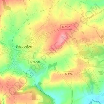
Cliquez sur la carte pour afficher l’altitude.
À propos de cette carte
Nom : Carte topographique Le Melleret, altitude, relief.
Altitude moyenne : 58 m
Altitude minimum : 7 m
Altitude maximum : 107 m
Autres cartes topographiques
Cliquez sur une carte pour visualiser sa topographie, son altitude et son relief.
Le Melleret
France > Normandie > Manche > Bricquebec-en-Cotentin > Bricquebec
Le Melleret, Bricquebec, Bricquebec-en-Cotentin, Cherbourg, Manche, Normandie, France métropolitaine, 50260, France
Altitude moyenne : 57 m
Catigny
France > Normandie > Manche > Bricquebec-en-Cotentin > Bricquebec > Catigny
Catigny, Bricquebec, Bricquebec-en-Cotentin, Cherbourg, Manche, Normandie, France métropolitaine, 50260, France
Altitude moyenne : 104 m
La Croix Blanche
France > Normandie > Manche > Bricquebec-en-Cotentin > Bricquebec
La Croix Blanche, Bricquebec, Bricquebec-en-Cotentin, Cherbourg, Manche, Normandie, France métropolitaine, 50260, France
Altitude moyenne : 89 m