
Carte topographique Igrexafeita
Carte interactive
Cliquez sur la carte pour afficher l’altitude.
À propos de cette carte
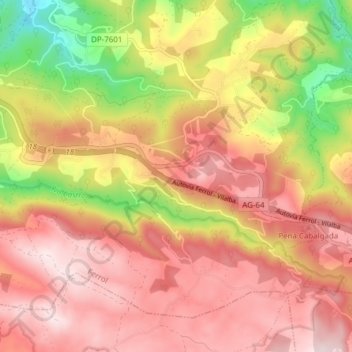
Nom : Carte topographique Igrexafeita, altitude, relief.
Lieu : Igrexafeita, San Sadurniño, Ferrol, La Coruña, Galicia, España (43.47288 -8.04425 43.51759 -7.96776)
Altitude moyenne : 349 m
Altitude minimum : 68 m
Altitude maximum : 532 m
Autres cartes topographiques
Cliquez sur une carte pour visualiser sa topographie, son altitude et son relief.
Bouzamaior
España > Galicia > Ferrol > San Sadurniño
Bouzamaior, Igrexafeita, San Sadurniño, Ferrol, La Coruña, Galicia, 15324, España
Altitude moyenne : 360 m