
Carte topographique Schloss Guttenburg
Carte interactive
Cliquez sur la carte pour afficher l’altitude.
À propos de cette carte
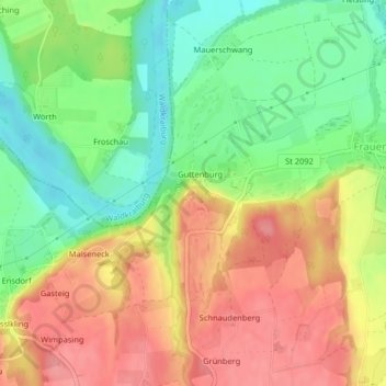
Nom : Carte topographique Schloss Guttenburg, altitude, relief.
Altitude moyenne : 427 m
Altitude minimum : 381 m
Altitude maximum : 472 m
Autres cartes topographiques
Cliquez sur une carte pour visualiser sa topographie, son altitude et son relief.
Heisting
Deutschland > Bayern > Landkreis Mühldorf am Inn > Kraiburg > Frauendorf
Heisting, Frauendorf, Kraiburg, Kraiburg am Inn (VGem), Landkreis Mühldorf am Inn, Bayern, 84562, Deutschland
Altitude moyenne : 412 m