
Carte topographique Northen Red Sea Region
Carte interactive
Cliquez sur la carte pour afficher l’altitude.
À propos de cette carte
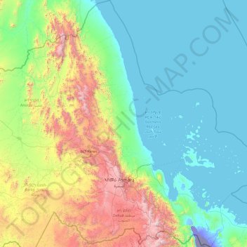
Nom : Carte topographique Northen Red Sea Region, altitude, relief.
Lieu : Northen Red Sea Region, Eritrea (14.36625 37.95768 18.07099 41.08500)
Altitude moyenne : 534 m
Altitude minimum : -124 m
Altitude maximum : 3 152 m
The Northern Red Sea Region borders the Anseba, Maekel (Central) and Debub (Southern) regions to the west, and the Southern Red Sea Region to the east. It has an area of around 27,800 km². The lowest point in Eritrea, Lake Kulul, is in this region. The topography of the region has coastal plains, which are hotter than the regions around the highland plateau. There are two rainy seasons, the heavier one during summer and the lighter one during spring. The climate and geography of the region along with other regions of Eritrea is similar to the one of Ethiopia. The hottest month is May recording temperatures up to 30 °C (86 °F), while the coldest month is December to February when it reaches freezing temperature. The region received around 508 mm (20.0 in) of rainfall and the soil is salty and not conducive for agriculture.
Autres cartes topographiques
Cliquez sur une carte pour visualiser sa topographie, son altitude et son relief.
Nefasit
Eritrea > Northen Red Sea Region
Nefasit, Northen Red Sea Region, Eritrea
Altitude moyenne : 1 856 m
Green Island
Eritrea > Northen Red Sea Region > Massawa
Green Island, Massawa, Northen Red Sea Region, Eritrea
Altitude moyenne : 165 m