
Faire un don
Équipez-vous pour votre prochaine aventure :
En tant que Partenaire Amazon, ce site perçoit une commission sur les achats éligibles sans surcoût pour vous.
Carte topographique Kloof
Cliquez sur la carte pour afficher l’altitude.
Faire un don
Équipez-vous pour votre prochaine aventure :
En tant que Partenaire Amazon, ce site perçoit une commission sur les achats éligibles sans surcoût pour vous.
Kloof
The further subdivisions and sale of portions of Richmond Farm No. 999 by the Field heirs after 1901 resulted in the birth of Kloof as a residential area: numerous plots were sold to wealthy Durban residents and businessmen, who built country house retreats close to the city, but (due to its 550 m above sea level elevation) removed from the Durban humidity and heat. These were particularly favoured by their wives and children during the long hot summer holidays.
Faire un don
Équipez-vous pour votre prochaine aventure :
En tant que Partenaire Amazon, ce site perçoit une commission sur les achats éligibles sans surcoût pour vous.
À propos de cette carte
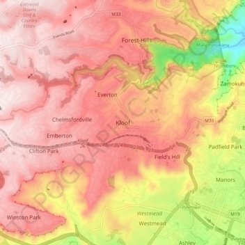
Nom : Carte topographique Kloof, altitude, relief.
Altitude moyenne : 480 m
Altitude minimum : 101 m
Altitude maximum : 673 m
Faire un don
Équipez-vous pour votre prochaine aventure :
En tant que Partenaire Amazon, ce site perçoit une commission sur les achats éligibles sans surcoût pour vous.
Autres cartes topographiques
Cliquez sur une carte pour visualiser sa topographie, son altitude et son relief.
Pigeon Valley
South Africa > KwaZulu-Natal > eThekwini Metropolitan Municipality > Durban
Altitude moyenne : 69 m
eThekwini Ward 32
South Africa > KwaZulu-Natal > eThekwini Metropolitan Municipality
Altitude moyenne : 25 m
Bluff Nature Reserve
South Africa > KwaZulu-Natal > eThekwini Metropolitan Municipality > Durban
Altitude moyenne : 38 m
Faire un don
Équipez-vous pour votre prochaine aventure :
En tant que Partenaire Amazon, ce site perçoit une commission sur les achats éligibles sans surcoût pour vous.
uMngeni River
South Africa > KwaZulu-Natal > eThekwini Metropolitan Municipality
Altitude moyenne : 598 m
Umgeni River
South Africa > KwaZulu-Natal > eThekwini Metropolitan Municipality > Queensburgh
Altitude moyenne : 131 m
Umbilo River
South Africa > KwaZulu-Natal > eThekwini Metropolitan Municipality > Durban
Altitude moyenne : 56 m
Umbilo River
South Africa > KwaZulu-Natal > eThekwini Metropolitan Municipality > Durban
Altitude moyenne : 56 m
Faire un don
Équipez-vous pour votre prochaine aventure :
En tant que Partenaire Amazon, ce site perçoit une commission sur les achats éligibles sans surcoût pour vous.
Umgeni River
South Africa > KwaZulu-Natal > eThekwini Metropolitan Municipality > Queensburgh
Altitude moyenne : 131 m
Inanda Dam
South Africa > KwaZulu-Natal > eThekwini Metropolitan Municipality
Altitude moyenne : 222 m
uMngeni River
South Africa > KwaZulu-Natal > eThekwini Metropolitan Municipality
Altitude moyenne : 598 m
Faire un don
Équipez-vous pour votre prochaine aventure :
En tant que Partenaire Amazon, ce site perçoit une commission sur les achats éligibles sans surcoût pour vous.
Plantations
South Africa > KwaZulu-Natal > eThekwini Metropolitan Municipality > Hillcrest
Altitude moyenne : 631 m