
Carte topographique Wang Nam Khiao
Carte interactive
Cliquez sur la carte pour afficher l’altitude.
À propos de cette carte
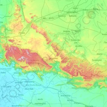
Nom : Carte topographique Wang Nam Khiao, altitude, relief.
Lieu : Wang Nam Khiao, Nakhon Ratchasima Province, 30370, Thailand (13.73104 101.14575 15.13104 102.54575)
Altitude moyenne : 250 m
Altitude minimum : 1 m
Altitude maximum : 1 302 m
Autres cartes topographiques
Cliquez sur une carte pour visualiser sa topographie, son altitude et son relief.
Phimai
Thailand > Nakhon Ratchasima Province
Phimai, Rang Ka Yai, Nakhon Ratchasima Province, 30110, Thailand
Altitude moyenne : 155 m
Nakhon Ratchasima Province
Thailand > Nakhon Ratchasima Province
Nakhon Ratchasima Province, Thailand
Altitude moyenne : 171 m
Nakhon Ratchasima
Thailand > Nakhon Ratchasima Province
Nakhon Ratchasima, Hua Thale, Nakhon Ratchasima Province, 30000, Thailand
Altitude moyenne : 195 m
Thap Lan National Park
Thailand > Nakhon Ratchasima Province
Thap Lan National Park, Nakhon Ratchasima Province, Thailand
Altitude moyenne : 309 m