
Carte topographique Boguchwała
Carte interactive
Cliquez sur la carte pour afficher l’altitude.
À propos de cette carte
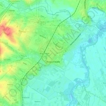
Nom : Carte topographique Boguchwała, altitude, relief.
Altitude moyenne : 218 m
Altitude minimum : 199 m
Altitude maximum : 261 m
Autres cartes topographiques
Cliquez sur une carte pour visualiser sa topographie, son altitude et son relief.
Głogów Małopolski
Poland > Subcarpathian Voivodeship > Rzeszów County
Głogów Małopolski, gmina Głogów Małopolski, Rzeszów County, Subcarpathian Voivodeship, 36-060, Poland
Altitude moyenne : 225 m