
Carte topographique Божица
Carte interactive
Cliquez sur la carte pour afficher l’altitude.
À propos de cette carte
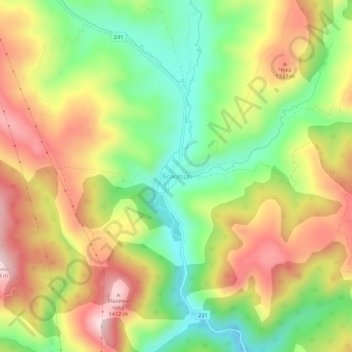
Nom : Carte topographique Божица, altitude, relief.
Altitude moyenne : 1 231 m
Altitude minimum : 1 058 m
Altitude maximum : 1 422 m
Autres cartes topographiques
Cliquez sur une carte pour visualiser sa topographie, son altitude et son relief.
Сухи Дол
Serbie > Serbie centrale > Пчињски управни округ > Општина Сурдулица > Сухи Дол
Сухи Дол, Општина Сурдулица, Пчињски управни округ, Serbie centrale, Serbie
Altitude moyenne : 921 m
Сурдулица
Serbie > Serbie centrale > Пчињски управни округ > Општина Сурдулица
Сурдулица, Општина Сурдулица, Пчињски управни округ, Serbie centrale, 17530, Serbie
Altitude moyenne : 683 m