
Carte topographique Columbia River
Carte interactive
Cliquez sur la carte pour afficher l’altitude.
À propos de cette carte
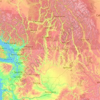
Nom : Carte topographique Columbia River, altitude, relief.
Altitude moyenne : 1 102 m
Altitude minimum : -2 m
Altitude maximum : 4 151 m
The Columbia's heavy flow and large elevation drop over a short distance, 2.16 feet per mile (40.9 cm/km), give it tremendous capacity for hydroelectricity generation. In comparison, the Mississippi drops less than 0.65 feet per mile (12.3 cm/km). The Columbia alone possesses one-third of the United States's hydroelectric potential. In 2012, the river and its tributaries accounted for 29 GW of hydroelectric generating capacity, contributing 44 percent of the total hydroelectric generation in the nation.
Autres cartes topographiques
Cliquez sur une carte pour visualiser sa topographie, son altitude et son relief.
Ashnola River
United States of America > Washington > Okanogan County
Ashnola River, Okanogan County, Washington, United States of America
Altitude moyenne : 2 019 m
Silver Star Mountain
United States of America > Washington > Okanogan County
Silver Star Mountain, Okanogan County, Washington, United States of America
Altitude moyenne : 2 161 m