
Faire un don
Équipez-vous pour votre prochaine aventure :
En tant que Partenaire Amazon, ce site perçoit une commission sur les achats éligibles sans surcoût pour vous.
Carte topographique Beechy
Cliquez sur la carte pour afficher l’altitude.
Faire un don
Équipez-vous pour votre prochaine aventure :
En tant que Partenaire Amazon, ce site perçoit une commission sur les achats éligibles sans surcoût pour vous.
À propos de cette carte
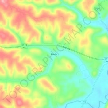
Nom : Carte topographique Beechy, altitude, relief.
Lieu : Beechy, Greenup County, Kentucky, United States (38.60452 -82.97406 38.64452 -82.93406)
Altitude moyenne : 230 m
Altitude minimum : 161 m
Altitude maximum : 315 m
Faire un don
Équipez-vous pour votre prochaine aventure :
En tant que Partenaire Amazon, ce site perçoit une commission sur les achats éligibles sans surcoût pour vous.
Autres cartes topographiques
Cliquez sur une carte pour visualiser sa topographie, son altitude et son relief.
Flatwoods
United States > Kentucky > Greenup County
The area now known as Flatwoods was originally named "Advance": Advance Methodist Church formed a Sunday school beginning in 1860. The name was later changed to "Cheap", after John Cheap, a blind clergyman. The original farming community returned to the name of "Advance" when a post office was established in…
Altitude moyenne : 194 m
Faire un don
Équipez-vous pour votre prochaine aventure :
En tant que Partenaire Amazon, ce site perçoit une commission sur les achats éligibles sans surcoût pour vous.
Bellefonte
United States > Kentucky > Greenup County
The city is located on a one-mile wide belt of relatively flat land that is approximately 100 feet higher in elevation than the nearby Ohio River valley. The unusual topography which is easily noticeable on topographical maps and aerial satellite imagery was created by the ancient Teays River. Larger than the…
Altitude moyenne : 188 m