
Carte topographique Taplejung
Carte interactive
Cliquez sur la carte pour afficher l’altitude.
Taplejung
Geographically Taplejung is a mountainous district located near to the world's third highest peak Kanchenjunga (8586 m). It is situated at elevation ranging from 670 metres (2,200 ft) to 8,586 metres (28,169 ft) from sea level. Tamur River is a main river in the district, which flows through the middle in the district dividing district in east and west Taplejung. Gunsa river, Simbuwa river and there are many tributaries of tamor are important source of freshwater. There are over than 60 rivers and streams in the district. Some glacial lakes are: Sinjenma Pokhari, Samdo Pokhari, Tin Pokhari, Kali Pokhari etc. The district includes many highest peaks eg. Gimmigela (7350 m), talung (7349 m), Kabru (7276 m), Nepal peak (7177 m), Kumbhkarna (7025 m) etc. Kanchenjunga Conservation Area is a protected area in the district which covers an area of 2,035 square kilometres (786 sq mi).
À propos de cette carte
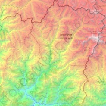
Nom : Carte topographique Taplejung, altitude, relief.
Lieu : Taplejung, Province #1, Nepal (27.26831 87.44430 27.95305 88.20153)
Altitude moyenne : 3 894 m
Altitude minimum : 568 m
Altitude maximum : 8 521 m
Autres cartes topographiques
Cliquez sur une carte pour visualiser sa topographie, son altitude et son relief.
Mount Everest
Nepal > Eastern Development Region > Tashi Dzom > Khumjung
The current official elevation of 8,848 m (29,029 ft), recognised by China and Nepal, was established by a 1955 Indian survey and subsequently confirmed by a Chinese survey in 1975.
Altitude moyenne : 7 841 m