
Faire un don
Équipez-vous pour votre prochaine aventure :
En tant que Partenaire Amazon, ce site perçoit une commission sur les achats éligibles sans surcoût pour vous.
Carte topographique Cinque Terre
Cliquez sur la carte pour afficher l’altitude.
Faire un don
Équipez-vous pour votre prochaine aventure :
En tant que Partenaire Amazon, ce site perçoit une commission sur les achats éligibles sans surcoût pour vous.
Cinque Terre
The Cinque Terre National Park was established on 6 October 1999 in recognition of the territory's considerable scenic, agricultural, historical and cultural value. Two years before, the area was added to the list of World Heritage Sites. The five medieval towns along the Ligurian Coast provide scenic views of rugged terrain reeled in with terraced stone walls, where the mountains of 'Appennino Ligure come straight to the sea. The form and disposition of the towns as they embrace topography embedded in the cliffs are a testament to the long history of settlement and the terraced cultivated lands to the agricultural heritage of the area. As the first Italian park created to safeguard a landscape that has been mostly built by humans, the Cinque Terre National Park and Protected Marine Area aim to protect cultural heritage of “the park of Man.” The site's location and topography is a vital part of the identity of Cinque Terre, whose extreme typological restraints and access to the coast inherently provide for a delicate relationship between man and the natural environment. That relationship has led to a dual existence, focused on both land and sea.For more than a thousand years, man has cut the steep slopes for terrace farming and vineyards while at sea maintaining a strong fishing culture. The beauty of Cinque Terre lies not in a pristine environment void of man, but rather the interplay of the two.
Faire un don
Équipez-vous pour votre prochaine aventure :
En tant que Partenaire Amazon, ce site perçoit une commission sur les achats éligibles sans surcoût pour vous.
À propos de cette carte
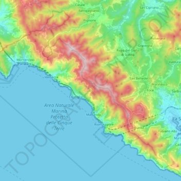
Nom : Carte topographique Cinque Terre, altitude, relief.
Lieu : Cinque Terre, Riomaggiore, Beverino, La Spezia, Liguria, Italy (44.06381 9.61537 44.18547 9.80712)
Altitude moyenne : 198 m
Altitude minimum : -2 m
Altitude maximum : 801 m
Faire un don
Équipez-vous pour votre prochaine aventure :
En tant que Partenaire Amazon, ce site perçoit une commission sur les achats éligibles sans surcoût pour vous.