Carte topographique New York
Carte interactive
Cliquez sur la carte pour afficher l’altitude.
À propos de cette carte
![Carte topographique New York, altitude, relief](/pub/maps/relation/b6t6/wxktf/thumbnail.jpg)
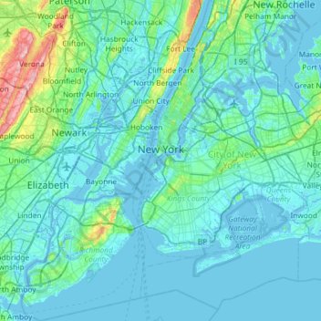
Nom : Carte topographique New York, altitude, relief.
Lieu : New York, États-Unis d'Amérique (40.47658 -74.25884 40.91763 -73.70023)
Altitude moyenne : 19 m
Altitude minimum : -6 m
Altitude maximum : 207 m
La superficie totale de la ville de New York est de 1 214 km2, dont 785 km2 de terres émergées et 429 km2 d'eau. L'altitude maximale est de 124,9 m au-dessus du niveau de la mer, sur Todt Hill à Staten Island.
Autres cartes topographiques
Cliquez sur une carte pour visualiser sa topographie, son altitude et son relief.
![Carte topographique Just Room Enough Island, altitude, relief](/pub/maps/way/mnm2/v3scl3q/icon.jpg)
Just Room Enough Island
États-Unis d'Amérique > New York > Jefferson County > Village of Alexandria Bay
Just Room Enough Island, Village of Alexandria Bay, Town of Alexandria, Jefferson County, New York, États-Unis d'Amérique
Altitude moyenne : 78 m
![Carte topographique Village of Tarrytown, altitude, relief](/pub/maps/relation/6wf3/x7zkl/icon.jpg)
Village of Tarrytown
États-Unis d'Amérique > New York > Westchester County
Village of Tarrytown, Town of Greenburgh, Westchester County, New York, 10591, États-Unis d'Amérique
Altitude moyenne : 54 m
![Carte topographique Village of Irvington, altitude, relief](/pub/maps/relation/l1z4/7f418/icon.jpg)
Village of Irvington
États-Unis d'Amérique > New York > Westchester County
Village of Irvington, Town of Greenburgh, Westchester County, New York, États-Unis d'Amérique
Altitude moyenne : 36 m
![Carte topographique Village of Croton-on-Hudson, altitude, relief](/pub/maps/relation/l114/9684s/icon.jpg)
Village of Croton-on-Hudson
États-Unis d'Amérique > New York > Westchester County > Town of Cortlandt
Village of Croton-on-Hudson, Town of Cortlandt, Westchester County, New York, 10520, États-Unis d'Amérique
Altitude moyenne : 42 m
![Carte topographique Town of Northampton, altitude, relief](/pub/maps/relation/3h1h/kq8ntf/icon.jpg)
Town of Northampton
États-Unis d'Amérique > New York > Fulton County
Town of Northampton, Fulton County, New York, 12134, États-Unis d'Amérique
Altitude moyenne : 298 m
![Carte topographique City of Kingston, altitude, relief](/pub/maps/relation/hr51/fsm1h/icon.jpg)
City of Kingston
États-Unis d'Amérique > New York > Ulster County
City of Kingston, Ulster County, New York, 12401, États-Unis d'Amérique
Altitude moyenne : 52 m
![Carte topographique Erie Canal, altitude, relief](/pub/maps/way/n23q/13hd8rr/icon.jpg)
Erie Canal
États-Unis d'Amérique > New York > Erie County > City of Tonawanda
Erie Canal, City of Tonawanda, Erie County, New York, États-Unis d'Amérique
Altitude moyenne : 177 m
![Carte topographique City of Utica, altitude, relief](/pub/maps/relation/5n5k/4pxm2/icon.jpg)
City of Utica
États-Unis d'Amérique > New York > Oneida County
City of Utica, Oneida County, New York, États-Unis d'Amérique
Altitude moyenne : 183 m
![Carte topographique Manhattan, altitude, relief](/pub/maps/relation/f5mt/4gpg3q/icon.jpg)
Manhattan
États-Unis d'Amérique > New York > New York County > New York
Manhattan, New York County, New York, États-Unis d'Amérique
Altitude moyenne : 16 m
![Carte topographique Town of Richmondville, altitude, relief](/pub/maps/relation/f9dn/fbjss8/icon.jpg)
Town of Richmondville
États-Unis d'Amérique > New York > Schoharie County
Town of Richmondville, Schoharie County, New York, États-Unis d'Amérique
Altitude moyenne : 492 m
![Carte topographique Town of Otisco, altitude, relief](/pub/maps/relation/kst6/b6q65k/icon.jpg)
Town of Otisco
États-Unis d'Amérique > New York > Onondaga County
Town of Otisco, Onondaga County, New York, 13110, États-Unis d'Amérique
Altitude moyenne : 375 m
![Carte topographique Wainscott, altitude, relief](/pub/maps/relation/3gmt/jb85k/icon.jpg)
Wainscott
États-Unis d'Amérique > New York > Suffolk County > Town of East Hampton
Wainscott, Town of East Hampton, Suffolk County, New York, 11975, États-Unis d'Amérique
Altitude moyenne : 13 m
![Carte topographique Central Park, altitude, relief](/pub/maps/way/9l9m/6xwm2tj/icon.jpg)
Central Park
États-Unis d'Amérique > New York > New York County > New York
Central Park, New York County, New York, États-Unis d'Amérique
Altitude moyenne : 26 m
![Carte topographique Town of Essex, altitude, relief](/pub/maps/relation/dpzs/rdlb18/icon.jpg)
Town of Essex
États-Unis d'Amérique > New York > Essex County
Town of Essex, Essex County, New York, 12936, États-Unis d'Amérique
Altitude moyenne : 71 m
![Carte topographique Village of Lattingtown, altitude, relief](/pub/maps/relation/h851/f391h/icon.jpg)
Village of Lattingtown
États-Unis d'Amérique > New York > Nassau County
Village of Lattingtown, Town of Oyster Bay, Nassau County, New York, 11560, États-Unis d'Amérique
Altitude moyenne : 20 m
![Carte topographique East Lancaster, altitude, relief](/pub/maps/node/3fgp/j8zg35k/icon.jpg)
East Lancaster
États-Unis d'Amérique > New York > Erie County > Town of Lancaster
East Lancaster, Town of Lancaster, Erie County, New York, 14086, États-Unis d'Amérique
Altitude moyenne : 216 m
![Carte topographique Rapids, altitude, relief](/pub/maps/relation/zhnx/9kvzs/icon.jpg)
Rapids
États-Unis d'Amérique > New York > Niagara County
Rapids, Town of Lockport, Niagara County, New York, États-Unis d'Amérique
Altitude moyenne : 179 m
![Carte topographique Saint Lawrence, altitude, relief](/pub/maps/node/hzrr/dlnxfrr/icon.jpg)
Saint Lawrence
États-Unis d'Amérique > New York
Saint Lawrence, Saint Lawrence County, New York, États-Unis d'Amérique
Altitude moyenne : 268 m
![Carte topographique Village of Kings Point, altitude, relief](/pub/maps/relation/sd1h/f39nh/icon.jpg)
Village of Kings Point
États-Unis d'Amérique > New York > Nassau County
Village of Kings Point, Town of North Hempstead, Nassau County, New York, 11024, États-Unis d'Amérique
Altitude moyenne : 9 m
![Carte topographique Town of Red House / Jóë́’hesta’, altitude, relief](/pub/maps/relation/4zm2/zft314/icon.jpg)
Town of Red House / Jóë́’hesta’
États-Unis d'Amérique > New York > Cattaraugus County
Town of Red House / Jóë́’hesta’, Cattaraugus County, New York, États-Unis d'Amérique
Altitude moyenne : 545 m
![Carte topographique Oneida, altitude, relief](/pub/maps/node/mc51/7dpgd51/icon.jpg)
Oneida
États-Unis d'Amérique > New York
Oneida, Oneida County, New York, États-Unis d'Amérique
Altitude moyenne : 385 m
![Carte topographique Town of Glen, altitude, relief](/pub/maps/relation/d3b3/tlqxm2/icon.jpg)
Town of Glen
États-Unis d'Amérique > New York > Montgomery County
Town of Glen, Montgomery County, New York, 12072, États-Unis d'Amérique
Altitude moyenne : 182 m
![Carte topographique Village of Williamsville, altitude, relief](/pub/maps/relation/h2m2/6fl9m/icon.jpg)
Village of Williamsville
États-Unis d'Amérique > New York > Erie County > Town of Amherst
Village of Williamsville, Town of Amherst, Erie County, New York, États-Unis d'Amérique
Altitude moyenne : 206 m
![Carte topographique Saratoga County, altitude, relief](/pub/maps/relation/w5f3/k6vlt6/icon.jpg)
Saratoga County
États-Unis d'Amérique > New York
Saratoga County, New York, États-Unis d'Amérique
Altitude moyenne : 218 m
![Carte topographique Loch Sheldrake, altitude, relief](/pub/maps/relation/mmm2/chml9m/icon.jpg)
Loch Sheldrake
États-Unis d'Amérique > New York > Sullivan County > Town of Fallsburg
Loch Sheldrake, Town of Fallsburg, Sullivan County, New York, États-Unis d'Amérique
Altitude moyenne : 448 m
![Carte topographique Village of Saranac Lake, altitude, relief](/pub/maps/relation/kgf3/x9ckl/icon.jpg)
Village of Saranac Lake
États-Unis d'Amérique > New York > Franklin County > Town of Harrietstown
Village of Saranac Lake, Town of Harrietstown, Franklin County, New York, États-Unis d'Amérique
Altitude moyenne : 502 m
![Carte topographique Kaaterskill High Peak, altitude, relief](/pub/maps/node/slnh/zgjpvs8/icon.jpg)
Kaaterskill High Peak
États-Unis d'Amérique > New York > Greene County > Town of Hunter
Kaaterskill High Peak, Town of Hunter, Greene County, New York, 12436, États-Unis d'Amérique
Altitude moyenne : 850 m
![Carte topographique Sterling Forest State Park, altitude, relief](/pub/maps/relation/khs8/zx6t5k/icon.jpg)
Sterling Forest State Park
États-Unis d'Amérique > New York > Orange County > Town of Warwick
Sterling Forest State Park, Town of Warwick, Orange County, New York, États-Unis d'Amérique
Altitude moyenne : 250 m
![Carte topographique City of Poughkeepsie, altitude, relief](/pub/maps/relation/hz51/fsh1h/icon.jpg)
City of Poughkeepsie
États-Unis d'Amérique > New York > Dutchess County
City of Poughkeepsie, Dutchess County, New York, 12601, États-Unis d'Amérique
Altitude moyenne : 49 m
![Carte topographique Town of Amherst, altitude, relief](/pub/maps/relation/djzs/j8rh5k/icon.jpg)
Town of Amherst
États-Unis d'Amérique > New York > Erie County
Town of Amherst, Erie County, New York, États-Unis d'Amérique
Altitude moyenne : 184 m
![Carte topographique Eagle Mountain, altitude, relief](/pub/maps/node/9nb3/9f79l51/icon.jpg)
Eagle Mountain
États-Unis d'Amérique > New York > Ulster County
Eagle Mountain, Ulster County, New York, États-Unis d'Amérique
Altitude moyenne : 893 m
![Carte topographique Manhattan, altitude, relief](/pub/maps/relation/7jz4/3jm5rr/icon.jpg)
Manhattan
États-Unis d'Amérique > New York > New York
Harlem, Manhattan Community Board 10, Manhattan, New York County, New York, États-Unis d'Amérique
Altitude moyenne : 16 m
![Carte topographique Liberty Island, altitude, relief](/pub/maps/relation/vq51/929ztp/icon.jpg)
Liberty Island
États-Unis d'Amérique > New York > New York County > New York
Liberty Island, Manhattan Community Board 1, Manhattan, New York County, New York, Hudson County, New York, États-Unis d'Amérique
Altitude moyenne : 0 m
![Carte topographique Niagara Falls, altitude, relief](/pub/maps/node/l7gp/5d7lq18/icon.jpg)
Niagara Falls
États-Unis d'Amérique > New York > Niagara County > Niagara Falls
Niagara Falls, Niagara County, New York, 14302, États-Unis d'Amérique
Altitude moyenne : 158 m
![Carte topographique Sparta, altitude, relief](/pub/maps/node/f49m/wpnqttf/icon.jpg)
Sparta
États-Unis d'Amérique > New York > Westchester County > Village of Ossining
Sparta, Village of Ossining, Town of Ossining, Westchester County, New York, 10562, États-Unis d'Amérique
Altitude moyenne : 52 m
![Carte topographique Town of Clermont, altitude, relief](/pub/maps/relation/c9cz/8958gp/icon.jpg)
Town of Clermont
États-Unis d'Amérique > New York > Columbia County
Town of Clermont, Columbia County, New York, États-Unis d'Amérique
Altitude moyenne : 81 m
![Carte topographique Town of Wilson, altitude, relief](/pub/maps/relation/frs8/k1rsf3/icon.jpg)
Town of Wilson
États-Unis d'Amérique > New York > Niagara County
Town of Wilson, Niagara County, New York, États-Unis d'Amérique
Altitude moyenne : 96 m
![Carte topographique Chutes du Niagara, altitude, relief](/pub/maps/way/rv5k/4znl4gp/icon.jpg)
Chutes du Niagara
États-Unis d'Amérique > New York > Niagara County > City of Niagara Falls
Chutes du Niagara, City of Niagara Falls, Niagara County, New York, États-Unis d'Amérique
Altitude moyenne : 173 m
![Carte topographique Rosendale, altitude, relief](/pub/maps/relation/d29m/k6hb3/icon.jpg)
Rosendale
États-Unis d'Amérique > New York > Ulster County
Rosendale, Town of Rosendale, Ulster County, New York, 12472, États-Unis d'Amérique
Altitude moyenne : 65 m
![Carte topographique Town of Indian Lake, altitude, relief](/pub/maps/relation/nmtj/nllrrr/icon.jpg)
Town of Indian Lake
États-Unis d'Amérique > New York > Hamilton County
Town of Indian Lake, Hamilton County, New York, États-Unis d'Amérique
Altitude moyenne : 625 m
![Carte topographique Rikers Island, altitude, relief](/pub/maps/relation/4sm2/38f8tj/icon.jpg)
Rikers Island
États-Unis d'Amérique > New York > New York
Rikers Island, The Bronx, New York, États-Unis d'Amérique
Altitude moyenne : 2 m
![Carte topographique Village of Lisle, altitude, relief](/pub/maps/relation/d4z4/76f18/icon.jpg)
Village of Lisle
États-Unis d'Amérique > New York > Broome County > Town of Lisle
Village of Lisle, Town of Lisle, Barker, Broome County, New York, États-Unis d'Amérique
Altitude moyenne : 348 m
![Carte topographique Village of Waddington, altitude, relief](/pub/maps/relation/d8z4/76618/icon.jpg)
Village of Waddington
États-Unis d'Amérique > New York > Saint Lawrence County
Village of Waddington, Town of Waddington, Saint Lawrence County, New York, 13694, États-Unis d'Amérique
Altitude moyenne : 80 m
![Carte topographique Town of Johnsburg, altitude, relief](/pub/maps/relation/bg57/7qbn3l/icon.jpg)
Town of Johnsburg
États-Unis d'Amérique > New York > Warren County
Town of Johnsburg, Warren County, New York, États-Unis d'Amérique
Altitude moyenne : 459 m
![Carte topographique Town of Woodstock, altitude, relief](/pub/maps/relation/2c3q/3w8k1h/icon.jpg)
Town of Woodstock
États-Unis d'Amérique > New York > Ulster County
Town of Woodstock, Ulster County, New York, États-Unis d'Amérique
Altitude moyenne : 332 m
![Carte topographique Town of Sandy Creek, altitude, relief](/pub/maps/relation/h651/7m31zs/icon.jpg)
Town of Sandy Creek
États-Unis d'Amérique > New York > Oswego County
Town of Sandy Creek, Oswego County, New York, États-Unis d'Amérique
Altitude moyenne : 161 m
![Carte topographique Dutchess County, altitude, relief](/pub/maps/relation/3c14/dzzgf3/icon.jpg)
Dutchess County
États-Unis d'Amérique > New York
Town of Hyde Park, Dutchess County, New York, États-Unis d'Amérique
Altitude moyenne : 91 m
![Carte topographique Town of Hermon, altitude, relief](/pub/maps/relation/fdgt/pwhlt6/icon.jpg)
Town of Hermon
États-Unis d'Amérique > New York > Saint Lawrence County
Town of Hermon, Saint Lawrence County, New York, États-Unis d'Amérique
Altitude moyenne : 201 m
![Carte topographique Ramapo, altitude, relief](/pub/maps/node/7pz4/lzw1jgp/icon.jpg)
Ramapo
États-Unis d'Amérique > New York > Rockland County
Ramapo, Town of Ramapo, Rockland County, New York, 10931, États-Unis d'Amérique
Altitude moyenne : 191 m
![Carte topographique Battery Park, altitude, relief](/pub/maps/way/b4kl/b9wlt6/icon.jpg)
Battery Park
États-Unis d'Amérique > New York > New York County > New York
Battery Park, Manhattan Community Board 1, Manhattan, New York County, New York, 10004, États-Unis d'Amérique
Altitude moyenne : 3 m