
Carte topographique Benton County
Carte interactive
Cliquez sur la carte pour afficher l’altitude.
À propos de cette carte
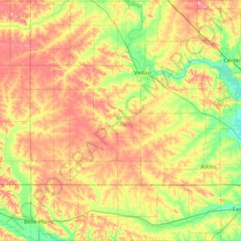
Nom : Carte topographique Benton County, altitude, relief.
Lieu : Benton County, Iowa, United States (41.86162 -92.29931 42.29905 -91.83110)
Altitude moyenne : 268 m
Altitude minimum : 224 m
Altitude maximum : 321 m
Autres cartes topographiques
Cliquez sur une carte pour visualiser sa topographie, son altitude et son relief.
Hinton
United States > Iowa > Plymouth County
Hinton, Plymouth County, Iowa, 51204, United States
Altitude moyenne : 362 m
Granger
United States > Iowa > Dallas County
Granger, Dallas County, Iowa, 50109, United States
Altitude moyenne : 274 m
Fertile
United States > Iowa > Worth County
Fertile, Worth County, Iowa, 50434, United States
Altitude moyenne : 364 m
Davenport
United States > Iowa > Scott County
Davenport, Scott County, Iowa, United States
Altitude moyenne : 205 m
Templeton
United States > Iowa > Carroll County
Templeton, Carroll County, Iowa, United States
Altitude moyenne : 434 m
Davenport
United States > Iowa > Scott County > Davenport
Davenport, Scott County, Iowa, 52801, United States
Altitude moyenne : 212 m
Iowa City
United States > Iowa > Johnson County > Iowa City
Iowa City, Johnson County, Iowa, 52240-5544, United States
Altitude moyenne : 225 m
Maharishi Vedic City
United States > Iowa > Jefferson County > Maharishi Vedic City
Maharishi Vedic City, Jefferson County, Iowa, United States
Altitude moyenne : 237 m
Pisgah
United States > Iowa > Harrison County > Pisgah
Pisgah, Harrison County, Iowa, United States
Altitude moyenne : 343 m
Gravity
United States > Iowa > Taylor County
Gravity, Taylor County, Iowa, United States
Altitude moyenne : 367 m
Des Moines
United States > Iowa > Polk County
Des Moines, Polk County, Iowa, United States
Altitude moyenne : 264 m
Iowa City
United States > Iowa > Iowa City
Iowa City, Johnson County, Iowa, United States
Altitude moyenne : 216 m