
Carte topographique Prospect Park
Carte interactive
Cliquez sur la carte pour afficher l’altitude.
À propos de cette carte
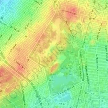
Nom : Carte topographique Prospect Park, altitude, relief.
Lieu : Prospect Park, Kings County, New York, United States (40.65135 -73.97942 40.67237 -73.96215)
Altitude moyenne : 34 m
Altitude minimum : 4 m
Altitude maximum : 62 m
Autres cartes topographiques
Cliquez sur une carte pour visualiser sa topographie, son altitude et son relief.
Grasmere Lake
United States > New York > New York
Grasmere Lake, Staten Island, New York, United States
Altitude moyenne : 27 m
Queens County
United States > New York > New York
Queens County, New York, United States
Altitude moyenne : 11 m
New York County
United States > New York > New York
New York County, New York, United States
Altitude moyenne : 16 m