
Faire un don
Équipez-vous pour votre prochaine aventure :
En tant que Partenaire Amazon, ce site perçoit une commission sur les achats éligibles sans surcoût pour vous.
Carte topographique Danubian Lowland
Cliquez sur la carte pour afficher l’altitude.
Faire un don
Équipez-vous pour votre prochaine aventure :
En tant que Partenaire Amazon, ce site perçoit une commission sur les achats éligibles sans surcoût pour vous.
À propos de cette carte
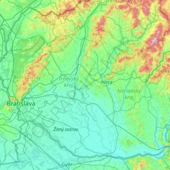
Nom : Carte topographique Danubian Lowland, altitude, relief.
Lieu : Danubian Lowland, Western Slovakia, Slovakia (47.73121 17.05696 48.84188 18.99439)
Altitude moyenne : 227 m
Altitude minimum : 102 m
Altitude maximum : 1 312 m
Faire un don
Équipez-vous pour votre prochaine aventure :
En tant que Partenaire Amazon, ce site perçoit une commission sur les achats éligibles sans surcoût pour vous.
Autres cartes topographiques
Cliquez sur une carte pour visualiser sa topographie, son altitude et son relief.
Bratislava
Slovakia > Region of Bratislava > District of Bratislava I > Old Town
The Carpathian mountain range begins in city territory with the Little Carpathians (Malé Karpaty). The Záhorie and Danubian lowlands stretch into Bratislava. The city's lowest point is at the Danube's surface at 126 metres (413 ft) above mean sea level, and the highest point is Devínska Kobyla at 514 metres…
Altitude moyenne : 175 m
Ďumbier
Slovakia > Region of Žilina > District of Liptovský Mikuláš > Liptovský Ján
Altitude moyenne : 1 669 m
Faire un don
Équipez-vous pour votre prochaine aventure :
En tant que Partenaire Amazon, ce site perçoit une commission sur les achats éligibles sans surcoût pour vous.
Faire un don
Équipez-vous pour votre prochaine aventure :
En tant que Partenaire Amazon, ce site perçoit une commission sur les achats éligibles sans surcoût pour vous.
Castle
Slovakia > Region of Nitra > District of Zlaté Moravce > Vieska nad Žitavou
Altitude moyenne : 187 m
Chopok
Slovakia > Region of Banská Bystrica > District of Brezno > Horná Lehota
Altitude moyenne : 1 642 m
Faire un don
Équipez-vous pour votre prochaine aventure :
En tant que Partenaire Amazon, ce site perçoit une commission sur les achats éligibles sans surcoût pour vous.
Chopok
Slovakia > Region of Banská Bystrica > District of Brezno > Horná Lehota
Altitude moyenne : 1 642 m
Faire un don
Équipez-vous pour votre prochaine aventure :
En tant que Partenaire Amazon, ce site perçoit une commission sur les achats éligibles sans surcoût pour vous.
Volovec / Wołowiec
Slovakia > Region of Žilina > District of Liptovský Mikuláš
There are two marked hiking trails which lead to the summit of Volovec, red and blue. A third, green one, connects with the blue one at the saddle beneath the mountain. All routes pose no technical difficulty and when taking into account the relatively large distance and altitude difference involved, the…
Altitude moyenne : 1 678 m
Mišúty
Slovakia > Region of Banská Bystrica > District of Banská Bystrica > Donovaly
Altitude moyenne : 1 041 m
Košické Hámre
Slovakia > Region of Košice > District of Košice - okolie > Košická Belá
Altitude moyenne : 443 m
Faire un don
Équipez-vous pour votre prochaine aventure :
En tant que Partenaire Amazon, ce site perçoit une commission sur les achats éligibles sans surcoût pour vous.
Nad lomom
Slovakia > Region of Prešov > District of Prešov > Drienovská Nová Ves
Altitude moyenne : 294 m
Kráľova hoľa
Slovakia > Region of Banská Bystrica > District of Brezno
Kráľova hoľa (Slovak pronunciation: [ˈkraːʎɔʋa ˈɦɔʎa]; German: Königsberg; Hungarian: Király-hegy, literally "King's Mountain") is the highest mountain (1,946 m) of the eastern part of the Low Tatras in central Slovakia. Four rivers rise at its foot: Čierny Váh, Hnilec, Hornád, and Hron. The…
Altitude moyenne : 1 653 m
Kriváň
Slovakia > Region of Prešov > District of Poprad > Vysoké Tatry
The relative elevations of the two mountains were determined by the English natural historian Robert Townson, who ascended both peaks in August 1793 and also made an early recorded comment on Kriváň's aesthetic appeal.
Altitude moyenne : 1 913 m
Faire un don
Équipez-vous pour votre prochaine aventure :
En tant que Partenaire Amazon, ce site perçoit une commission sur les achats éligibles sans surcoût pour vous.
Gerlachovský štít
Slovakia > Region of Prešov > District of Poprad
Gerlachovský štít (Slovak pronunciation, translated into English as Gerlachov Peak, German: Gerlsdorfer Spitze, Hungarian: Gerlachfalvi-csúcs), informally referred to as Gerlach, is the highest peak in the High Tatras, in Slovakia, and in the Carpathian Mountains. Its elevation is usually listed at 2654.4…
Altitude moyenne : 2 103 m
Medený vodopád
Slovakia > Region of Prešov > District of Poprad > Vysoké Tatry
Altitude moyenne : 2 004 m
Faire un don
Équipez-vous pour votre prochaine aventure :
En tant que Partenaire Amazon, ce site perçoit une commission sur les achats éligibles sans surcoût pour vous.
Danube
Slovakia > Region of Bratislava > District of Senec > Bratislava > Čunovo
Altitude moyenne : 125 m
Faire un don
Équipez-vous pour votre prochaine aventure :
En tant que Partenaire Amazon, ce site perçoit une commission sur les achats éligibles sans surcoût pour vous.
Kriváň
Slovakia > Region of Prešov > District of Poprad
The relative elevations of the two mountains were determined by the English natural historian Robert Townson, who ascended both peaks in August 1793 and also made an early recorded comment on Kriváň's aesthetic appeal.
Altitude moyenne : 1 913 m
Faire un don
Équipez-vous pour votre prochaine aventure :
En tant que Partenaire Amazon, ce site perçoit une commission sur les achats éligibles sans surcoût pour vous.
Veľká Javorina
Slovakia > Region of Trenčín > District of Nové Mesto nad Váhom
The massif of Velká Javořina is located in the southwest part of the White Carpathians and is built of flysch rocks with significant thickness, in which layers of sandstone (dating from the Upper Cretaceous to the Lower Paleocene) and fine-grained marine sediments (shales and marls) rhythmically repeat. The…
Altitude moyenne : 774 m
Rysy
Slovakia > Region of Prešov > District of Poprad
It is possible to reach the peak from the Slovak side, starting at Štrbské pleso and passing Chata pod Rysmi, a mountain chalet at an altitude of 2,250 m (7,380 ft). Between November 1 and June 15, the trail and chalet on the Slovak side are closed.
Altitude moyenne : 2 005 m
Faire un don
Équipez-vous pour votre prochaine aventure :
En tant que Partenaire Amazon, ce site perçoit une commission sur les achats éligibles sans surcoût pour vous.
Vodná nádrž Veľká Domaša
Slovakia > Region of Prešov > District of Vranov nad Topľou > Nová Kelča
Domaša is spread over the area of the districts of Vranov nad Topľou and Stropkov at the average altitude of 156 m (512 ft). With an agreeable climate and an average temperature of 23 °C (73 °F) it guarantees pleasant swimming in clean water from June to mid-September.
Altitude moyenne : 268 m
Tatralandia
Slovakia > Region of Žilina > District of Liptovský Mikuláš > Liptovský Mikuláš
Altitude moyenne : 590 m
Faire un don
Équipez-vous pour votre prochaine aventure :
En tant que Partenaire Amazon, ce site perçoit une commission sur les achats éligibles sans surcoût pour vous.
Nižnoslanská Baňa
Slovakia > Region of Košice > District of Rožňava > Nižná Slaná
Altitude moyenne : 503 m
Faire un don
Équipez-vous pour votre prochaine aventure :
En tant que Partenaire Amazon, ce site perçoit une commission sur les achats éligibles sans surcoût pour vous.
Veľkobielske jazero "Šutrovka"
Slovakia > Region of Bratislava > District of Senec > Veľký Biel
Altitude moyenne : 127 m
Faire un don
Équipez-vous pour votre prochaine aventure :
En tant que Partenaire Amazon, ce site perçoit une commission sur les achats éligibles sans surcoût pour vous.
Faire un don
Équipez-vous pour votre prochaine aventure :
En tant que Partenaire Amazon, ce site perçoit une commission sur les achats éligibles sans surcoût pour vous.
Pod Holým vrchom
Slovakia > Region of Trnava > District of Piešťany > Dolný Lopašov
Altitude moyenne : 256 m
Havran
Slovakia > Region of Prešov > District of Poprad > Tatranská Javorina
Altitude moyenne : 1 624 m
Michalovce
Slovakia > Region of Košice > District of Michalovce > Michalovce > Michalovce
Altitude moyenne : 113 m
Faire un don
Équipez-vous pour votre prochaine aventure :
En tant que Partenaire Amazon, ce site perçoit une commission sur les achats éligibles sans surcoût pour vous.
Faire un don
Équipez-vous pour votre prochaine aventure :
En tant que Partenaire Amazon, ce site perçoit une commission sur les achats éligibles sans surcoût pour vous.
Rysy
Slovakia > Region of Prešov > District of Poprad
It is possible to reach the peak from the Slovak side, starting at Štrbské pleso and passing Chata pod Rysmi, a mountain chalet at an altitude of 2,250 m (7,380 ft). Between November 1 and June 15, the trail and chalet on the Slovak side are closed.
Altitude moyenne : 2 005 m
Faire un don
Équipez-vous pour votre prochaine aventure :
En tant que Partenaire Amazon, ce site perçoit une commission sur les achats éligibles sans surcoût pour vous.
Východná
Slovakia > Region of Žilina > District of Liptovský Mikuláš > Východná
Altitude moyenne : 798 m
Oravský Podzámok
Slovakia > Region of Žilina > District of Dolný Kubín > Oravský Podzámok
Altitude moyenne : 625 m
Devín Castle
Slovakia > Region of Bratislava > Bratislava > District of Bratislava IV > Devín
The cliff (elevation 212 meters) is an ideal place for a fort due to its position at the confluence of the Danube and Morava rivers. The fort watches over an important trade route along the Danube as well as one branch of the Amber Road.
Altitude moyenne : 175 m
Faire un don
Équipez-vous pour votre prochaine aventure :
En tant que Partenaire Amazon, ce site perçoit une commission sur les achats éligibles sans surcoût pour vous.
Rudno
Slovakia > Region of Žilina > District of Turčianske Teplice > Rudno > Rudno
Altitude moyenne : 525 m
Faire un don
Équipez-vous pour votre prochaine aventure :
En tant que Partenaire Amazon, ce site perçoit une commission sur les achats éligibles sans surcoût pour vous.
Poprad
Slovakia > Region of Prešov > District of Poprad > Poprad > Poprad
International Poprad–Tatry Airport from 1938, is an airport with the highest elevations in Central Europe. It also offers scheduled flights to London.
Altitude moyenne : 699 m
Benda
Slovakia > Region of Banská Bystrica > District of Veľký Krtíš > Seľany
Altitude moyenne : 317 m
Faire un don
Équipez-vous pour votre prochaine aventure :
En tant que Partenaire Amazon, ce site perçoit une commission sur les achats éligibles sans surcoût pour vous.
Hrochoť
Slovakia > Region of Banská Bystrica > District of Banská Bystrica > Hrochoť > Hrochoť
Altitude moyenne : 626 m
Hermanovce nad Topľou
Slovakia > Region of Prešov > District of Vranov nad Topľou > Hermanovce nad Topľou > Hermanovce nad Topľou
Altitude moyenne : 338 m
Old Town
Slovakia > Region of Bratislava > District of Bratislava I > Old Town > Old Town
Altitude moyenne : 159 m
Faire un don
Équipez-vous pour votre prochaine aventure :
En tant que Partenaire Amazon, ce site perçoit une commission sur les achats éligibles sans surcoût pour vous.
Ružinov
Slovakia > Region of Bratislava > District of Bratislava II > Ružinov > Ružinov
Altitude moyenne : 143 m
Stará Huta
Slovakia > Region of Banská Bystrica > District of Detva > Stará Huta > Stará Huta
Altitude moyenne : 731 m
Pozdišovce
Slovakia > Region of Košice > District of Michalovce > Pozdišovce > Pozdišovce
Altitude moyenne : 129 m
Faire un don
Équipez-vous pour votre prochaine aventure :
En tant que Partenaire Amazon, ce site perçoit une commission sur les achats éligibles sans surcoût pour vous.
Jaslovské Bohunice
Slovakia > Region of Trnava > District of Trnava > Jaslovské Bohunice > Jaslovské Bohunice
Altitude moyenne : 169 m
Ochodnica
Slovakia > Region of Žilina > District of Kysucké Nové Mesto > Ochodnica > Ochodnica
Altitude moyenne : 502 m
Strakošovce
Slovakia > Region of Žilina > District of Bytča > Štiavnik > Strakošovce
Altitude moyenne : 648 m
Faire un don
Équipez-vous pour votre prochaine aventure :
En tant que Partenaire Amazon, ce site perçoit une commission sur les achats éligibles sans surcoût pour vous.
Chopok
Slovakia > Region of Banská Bystrica > District of Brezno > Horná Lehota
Altitude moyenne : 1 642 m
Druhý Mních / Zadni Mnich
Slovakia > Region of Prešov > District of Poprad > Vysoké Tatry
Altitude moyenne : 1 921 m
Faire un don
Équipez-vous pour votre prochaine aventure :
En tant que Partenaire Amazon, ce site perçoit une commission sur les achats éligibles sans surcoût pour vous.
Častá
Slovakia > Region of Bratislava > District of Pezinok
The village lies at an altitude of 245 meters and covers an area of 35.24 km². It has population of 2,078 people.
Altitude moyenne : 262 m