
Carte topographique Biwa Lake
Carte interactive
Cliquez sur la carte pour afficher l’altitude.
À propos de cette carte
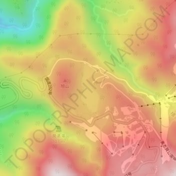
Nom : Carte topographique Biwa Lake, altitude, relief.
Altitude moyenne : 1 368 m
Altitude minimum : 891 m
Altitude maximum : 1 696 m
Autres cartes topographiques
Cliquez sur une carte pour visualiser sa topographie, son altitude et son relief.
Yamanouchi
Japan > Chubu Region > Yamanouchi
Yamanouchi, Shimotakai County, Nagano Prefecture, Chubu Region, 3810401, Japan
Altitude moyenne : 726 m