
Carte topographique Cahir
Carte interactive
Cliquez sur la carte pour afficher l’altitude.
À propos de cette carte
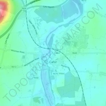
Nom : Carte topographique Cahir, altitude, relief.
Altitude moyenne : 58 m
Altitude minimum : 36 m
Altitude maximum : 171 m
Autres cartes topographiques
Cliquez sur une carte pour visualiser sa topographie, son altitude et son relief.
Ring Hill
Ring Hill, The Municipal District of Thurles, County Tipperary, Munster, Ireland
Altitude moyenne : 315 m
Cashel
Cashel, The Municipal District of Cahir — Cashel, County Tipperary, Munster, Ireland
Altitude moyenne : 115 m
The Municipal District of Cahir — Cashel
The Municipal District of Cahir — Cashel, County Tipperary, Munster, Ireland
Altitude moyenne : 143 m
Southhill
Southhill, Nenagh Rural, The Municipal District of Nenagh, County Tipperary, Munster, Ireland
Altitude moyenne : 76 m
The Municipal District of Nenagh
The Municipal District of Nenagh, County Tipperary, Munster, Ireland
Altitude moyenne : 116 m
Lattin
Lattin, The Municipal District of Cahir — Cashel, County Tipperary, Munster, Ireland
Altitude moyenne : 134 m
Haywood
Haywood, Clonmel Rural, The Borough District of Clonmel, County Tipperary, Munster, Ireland
Altitude moyenne : 55 m
The Municipal District of Carrick-on-Suir
The Municipal District of Carrick-on-Suir, County Tipperary, Munster, Ireland
Altitude moyenne : 118 m
The Municipal District of Thurles
The Municipal District of Thurles, County Tipperary, Munster, Ireland
Altitude moyenne : 144 m
Forest
Forest, Drom, The Municipal District of Thurles, County Tipperary, Munster, Ireland
Altitude moyenne : 113 m