
Faire un don
Équipez-vous pour votre prochaine aventure :
En tant que Partenaire Amazon, ce site perçoit une commission sur les achats éligibles sans surcoût pour vous.
Carte topographique Roxas
Cliquez sur la carte pour afficher l’altitude.
Faire un don
Équipez-vous pour votre prochaine aventure :
En tant que Partenaire Amazon, ce site perçoit une commission sur les achats éligibles sans surcoût pour vous.
Roxas
The landscape of Roxas is relatively compose of flatlands with minimal rise at certain point with base mountain elevations on the eastern part, on the parts of Sinamar, Simimbaan and San Placido. It is approximately 90% of the land area comprising the town can be described as low-lying hills with rolling terrain and an elevation of 200 feet or 61 meters above sea level. The town is dissected by creeks, river and waterways acting as natural drainage from waters coming from the uplands. The Siffu River, a connection from Ilog ng Cagayan(Cagayan River) traverse west ward from its diversion from Paracelis to Tuguegarao City supplying the rice fields with irrigation.
Faire un don
Équipez-vous pour votre prochaine aventure :
En tant que Partenaire Amazon, ce site perçoit une commission sur les achats éligibles sans surcoût pour vous.
À propos de cette carte
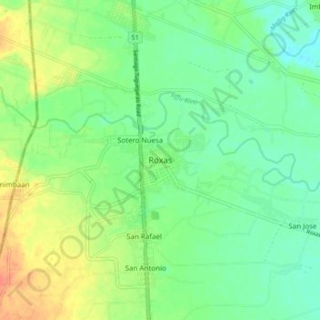
Nom : Carte topographique Roxas, altitude, relief.
Lieu : Roxas, Isabela, Cagayan Valley, 3320, Philippines (17.08192 121.57992 17.16192 121.65992)
Altitude moyenne : 59 m
Altitude minimum : 42 m
Altitude maximum : 86 m
Faire un don
Équipez-vous pour votre prochaine aventure :
En tant que Partenaire Amazon, ce site perçoit une commission sur les achats éligibles sans surcoût pour vous.
Autres cartes topographiques
Cliquez sur une carte pour visualiser sa topographie, son altitude et son relief.