
Carte topographique Keith
Carte interactive
Cliquez sur la carte pour afficher l’altitude.
À propos de cette carte
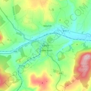
Nom : Carte topographique Keith, altitude, relief.
Lieu : Keith, Moray, Scotland, AB55 5FF, United Kingdom (57.50273 -2.99233 57.58273 -2.91233)
Altitude moyenne : 180 m
Altitude minimum : 96 m
Altitude maximum : 364 m
Autres cartes topographiques
Cliquez sur une carte pour visualiser sa topographie, son altitude et son relief.
Lossiemouth
United Kingdom > Scotland > Moray
Lossiemouth, Moray, Scotland, IV31 6NU, United Kingdom
Altitude moyenne : 3 m
Findhorn Ecovillage
United Kingdom > Scotland > Moray > Findhorn > Findhorn Ecovillage
Findhorn Ecovillage, Findhorn, Moray, Scotland, IV36 3TZ, United Kingdom
Altitude moyenne : 3 m
Forres
United Kingdom > Scotland > Moray > Forres
Forres, Moray, Scotland, IV36 1NX, United Kingdom
Altitude moyenne : 31 m