
Carte topographique Deadhorse
Carte interactive
Cliquez sur la carte pour afficher l’altitude.
À propos de cette carte
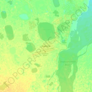
Nom : Carte topographique Deadhorse, altitude, relief.
Lieu : Deadhorse, North Slope, Alaska, United States (70.03995 -148.62182 70.35995 -148.30182)
Altitude moyenne : 15 m
Altitude minimum : -17 m
Altitude maximum : 62 m
In February 2023, a "high altitude object" about the size of a small car was shot down near the area after a decision by President Joe Biden.
Autres cartes topographiques
Cliquez sur une carte pour visualiser sa topographie, son altitude et son relief.
Wainwright
United States > Alaska > North Slope
Wainwright, North Slope, Alaska, 99782, United States
Altitude moyenne : 5 m
Howe Island
United States > Alaska > North Slope
Howe Island, North Slope, Alaska, United States
Altitude moyenne : 0 m
Igloo Mountain
United States > Alaska > North Slope
Igloo Mountain, North Slope, Alaska, United States
Altitude moyenne : 592 m
Prudhoe Bay
United States > Alaska > North Slope
Prudhoe Bay, North Slope, Alaska, 99734, United States
Altitude moyenne : 10 m
Utqiaġvik
United States > Alaska > North Slope
Utqiaġvik, North Slope, Alaska, 99273, United States
Altitude moyenne : 4 m